


- Base Value(2025): 2809 Mn
- Forecast Value (2035): 14211 Mn
- CAGR (2035): 17.3%
Aerial Inspection Services Market Outlook (2025 to 2035)
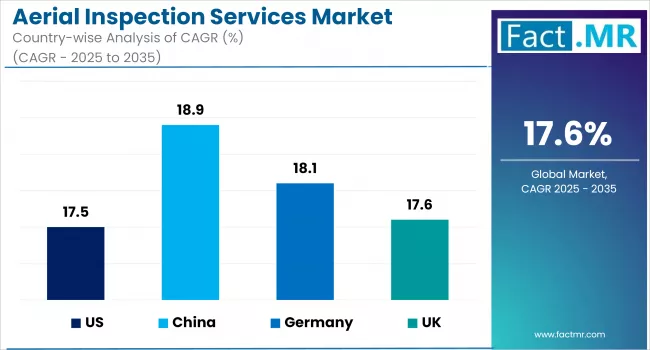
The global aerial inspection services market is expected to reach USD 14,211 million by 2035, up from USD 2,323 million in 2024. During the forecast period (2025 to 2035), the industry is projected to expand at a CAGR of 17.6%.
The aerial inspection services market is driven by the rising demand for safer, cost-efficient monitoring of critical infrastructure, as well as technological advances in drones, AI analytics, and sensors that enable real-time data capture, anomaly detection, and predictive maintenance.
| Report Attributes | Details |
|---|---|
| Estimated Size (2025E) | USD 2,809 million |
| Projected Value (2035F) | USD 14,211 million |
| Value-based CAGR (2025 to 2035) | 17.6% |
What are the drivers of the Aerial Inspection Services Market?
The aerial inspection services market is experiencing a high rate of growth driven by rising demand for non-intrusive, high-precision monitoring across critical infrastructure sectors. Industries such as energy, utilities, oil and gas, and transportation are shifting towards the use of aerial platforms instead of manual inspection to make their operations safer, minimize maintenance time, and achieve cost-effectiveness.
A fundamental enabling aspect is technological advancement. Advanced payloads, such as thermal sensors, LiDAR, and high-resolution imaging, are being fitted on drones to revolutionize field data collection. Real-time prediction, maintenance planning, anomaly detection, and real-time reporting can be achieved by integrating AI and machine learning into such platforms.
Environmental and ESG considerations are also influencing decision-making. Replacing helicopter-based inspections with drones significantly reduces carbon emissions and enhances worker safety. Moreover, the current worldwide growth of renewable energy infrastructure is generating long-term demand for scalable, cost-effective inspection solutions.
In general, a combination of regulatory support, technological maturity, and sustainability objectives is positioning the aerial inspection services along the path to becoming one of the most important elements of asset management solutions in the capital-intensive sectors.
What are the regional trends of the Aerial Inspection Services Market?
North America leads the global aerial inspection services market, driven by progressive drone regulations, significant infrastructure investments, and widespread adoption across the energy, telecommunications, and transportation sectors. The United States, in particular, benefits from a mature regulatory environment under the FAA and is at the forefront of integrating drones into grid, rail, and pipeline inspections.
Europe is demonstrating strong growth, driven by environmental compliance, automation goals, and aging infrastructure. Countries such as Germany, France, and the United Kingdom are deploying aerial inspection solutions in wind farms, electrical transmission lines, and rail systems. EU mandates around renewable energy targets and worker safety are further reinforcing market adoption.
Asia Pacific is the fastest-growing region. China is leveraging drones for 5G infrastructure rollout, mining, and urban planning, backed by large-scale smart city initiatives. India is expanding its use of drones in railways, energy corridors, and industrial safety programs. Japan’s focus is on precision monitoring for aging infrastructure and high-density urban assets.
The Middle East and Africa are increasingly deploying drones for surveillance and inspection of oil fields, utility lines, and desert infrastructure, particularly in Gulf Cooperation Council countries. Latin America, led by Brazil and Mexico, is seeing growing adoption across agriculture, energy, and public works as regulatory frameworks evolve and pilot projects expand.
What are the challenges and restraining factors of the Aerial Inspection Services Market?
Although the market has high growth potential, the aerial inspection services market faces several challenges that may hinder adoption. One of the main issues is regulatory fragmentation, which is particularly prevalent in developing economies with undefined or inconsistent drone policies. Legal and operational challenges may arise due to the lack of clarity regarding BVLOS operations and the rights to data use.
Upfront costs also present a barrier. Drone solutions that have adopted the advantages of superior sensors, AI-powered data analytics platforms, and automated data pipelines are highly expensive to implement. These capital requirements are prohibitive to the small and medium-sized service providers, especially in price-sensitive markets.
Another operational risk is environmental limitations. Unfavorable weather conditions like winds, rain, and fog may cause delays in inspection and data quality deterioration. Moreover, the shortage of experts in drone control and qualified data analysts leads to the inability to scale the services in most areas.
The privacy of data and security is a growing concern since drones are being deployed to survey sensitive installations. Poor protection of data in transmission, processing, or storage can result in breaches and lower client confidence.
Furthermore, the lack of standardized inspection protocols and data formats complicates integration with enterprise asset management systems. Without standardization, benchmarking and cross-platform analytics remain limited. Addressing these structural limitations is essential for unlocking the full value of aerial inspection services.
Country-Wise Insights
Regulatory Enablement and Grid Modernization Fuel U.S. Aerial Inspection Momentum
The U.S. aerial inspection services industry is experiencing strong expansion, fueled by regulatory support and a country-wide trend toward grid enhancement and asset digitalization. The Federal Aviation Administration (FAA) has established lenient drone use regulations, such as increased BVLOS (Beyond Visual Line of Sight) pilot programs, which are empowering commercial UAV deployment on an enormous scale.
Power utilities and oil & gas operators are using drone-based inspection to lower operating expenses, increase safety, and comply with regulations. Widespread wildfire danger in the western U.S. has also seen increased use of drones in vegetation management and infrastructure monitoring. The Department of Energy's investment in smart grid infrastructure is simultaneously driving long-term demand for UAV-aided inspection technologies.
Technological innovation is a major contributor as well, with AI-enabled data analysis, live cloud upload, and automated flight planning becoming the new standard. With ESG targets picking up, drone inspections are becoming increasingly viewed as a greener, lower-emitting option compared to helicopters and conventional surveying methods.
Engineering Precision and Industrial Safety Drive Germany’s UAV Adoption
Germany’s aerial inspection services market is advancing rapidly, fueled by the country’s industrial safety regulations, precision engineering culture, and strong environmental ethos. German enterprises are early adopters of drone-based inspections in sectors such as wind energy, automotive manufacturing, and rail infrastructure, where high reliability and regulatory compliance are paramount.
The Federal Ministry of Transport and Digital Affairs is also actively driving the safe operation of drones, such as integrating UAVs into controlled airspace and supporting corridor-based drone logistics. Germany's promotion of renewable energy, especially offshore wind power, is creating strong demand for predictive and routine inspections that are drone and digital twin powered.
Sensor payload innovation, particularly thermal imaging and 3D photogrammetry, is raising the value proposition for drones in the inspection of aging and complex infrastructure. In addition, the nation's strong support ecosystem of industrial automation companies and data analytics vendors is speeding up the integration of UAV activities with Industry 4.0 structures. These trends are making Germany a regional hub in intelligent asset monitoring and cutting-edge inspection technology.
Urban Infrastructure Demands and Smart Tech Fuel China’s UAV Surge
China's market for aerial inspection is growing strongly, driven by urbanization at a high pace, competitive construction of infrastructure, and policy-driven smart city projects. Government stimulus in the form of national guidelines for commercial deployment of UAVs and subsidies for research and development of drone assembly is driving adoption across sectors like power transmission, construction, and telecommunication.
State Grid Corporation of China and other big utility operators are increasingly employing drones to inspect power lines and substations in remote and mountainous regions. Meanwhile, China's massive rollout of 5G has produced huge demand for drone inspections of telecommunication towers and city installations.
Consumer-oriented innovation is also booming. Firms are combining AI-powered defect recognition, edge computing, and self-driving navigation to provide low-latency, high-frequency inspection services. The cultural focus on digital transformation and optimized safety is turning aerial inspections into a necessary instrument for dealing with China's highly populated urban infrastructure. Additionally, localized mass production of drones guarantees cost-effectiveness as well as rapid technology diffusion across regions.
Category-Wise Analysis
Visuals Inspection Enhances Real-Time Operational Visibility
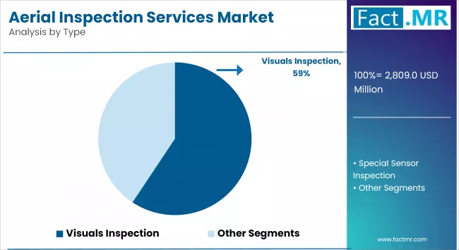
The visual inspection market is experiencing high adoption as sectors seek quicker, safer, and more affordable inspection methods. This form of aerial inspection uses high-definition video and photo capture to capture infrastructure, equipment, and construction status. It is highly effective for real-time anomaly detection and regular checks across various industries, including energy, construction, and agriculture. Visual inspection eliminates the need for manual climbs or shutdowns, reducing downtime and safety hazards. With the assistance of AI and image processing software, defects or corrosion can now be marked instantly.
Moreover, with real-time streaming capabilities, inspections can be remotely observed by engineers and stakeholders. As digital asset management takes center stage, demand for visual inspection is likely to surge. Sustainability in the environment is another major driver, with drone inspection cutting the carbon footprint of conventional field surveys. Overall, visual inspection plays a central role in the digitization and modernization of infrastructure management.
UAV (Drones) Propel Inspection Efficiency Across Verticals
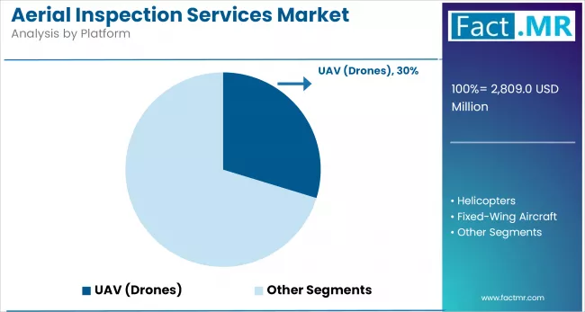
Unmanned aerial vehicles (UAVs), commonly known as drones, have revolutionized aerial inspection by offering unparalleled flexibility, lower operational costs, and high-resolution data capture. They are now indispensable in sectors like power generation, agriculture, real estate, and telecommunications. UAVs eliminate the need for scaffolding, helicopters, or manual inspection teams, especially in hazardous environments.
They are widely adopted for their ability to access confined, high, or remote locations quickly. With the development of autonomous flight, obstacle sensing, and extended transmission, UAVs now enable massive-scale inspection with minimal human interaction.
Regulatory agencies throughout North America and Europe are opening applications for commercial drone use, promoting the extended deployment of these devices. Advances in battery life extension and real-time analysis of imaging data have enhanced their effectiveness, providing instant feedback to decision-makers via cloud-based computing.
UAVs also facilitate sustainability objectives through reduced emissions compared to traditional inspection hardware. As industries move toward predictive maintenance and digital twins, UAVs are poised to remain at the forefront of aerial inspection technology.
LiDAR Elevates Precision in Infrastructure and Terrain Mapping
LiDAR (Light Detection and Ranging) technology has become integral to aerial inspection due to its unmatched ability to capture highly accurate, three-dimensional representations of terrain and infrastructure. Its application is rapidly growing in sectors such as mining, construction, forestry, and transportation, where precision is crucial.
Mounted on drones or aircraft, LiDAR enables operators to collect data even in low-visibility environments such as dense forests or uneven terrain. This makes it ideal for tasks like power line mapping, flood modeling, and construction site grading. The increasing adoption of smart city initiatives and infrastructure upgrades globally has spurred demand for detailed geospatial data, where LiDAR excels.
Software integrations allow LiDAR to be combined with GIS platforms for automated analysis and modeling. Moreover, the falling costs of LiDAR hardware and the emergence of lightweight, UAV-compatible systems are democratizing access to this high-end technology. Its growing use in renewable energy and environmental monitoring further strengthens its long-term market outlook.
Competitive Analysis
Key players in the aerial inspection services industry include Cyberhawk, AERIUM Analytics, EagleHawk, DDC - Smart Inspections, DJM Aerial Solutions, Astral Aerial Solutions, Aerodrome, Aero Enterprise, Aerial Vision Ltd, and Aerial Drone Solutions.
The aerial inspection services market is growing due to the increasing demand for safe, efficient, and cost-effective asset inspection in industries such as energy, infrastructure, and utilities. Demand for real-time data, minimal downtime, and reduced human risk is propelling growth.
Companies are innovating with AI-driven analytics, autonomous drone systems, and advanced imaging technologies, such as LiDAR and thermal sensors. Sustainability is also gaining focus, with efforts toward low-emission drone operations and digital workflows. These developments are enhancing operational efficiency and reshaping global inspection standards.
Recent Development
- In April 2025, HAECO launched drone-assisted aircraft inspection trials at its U.S. facilities, aiming to revolutionize maintenance processes. The drone system enhances inspection efficiency, accuracy, and safety by rapidly capturing high-resolution imagery, reducing downtime and technician exposure. This innovation aligns with HAECO’s commitment to smart aviation maintenance solutions.
- In March 2025, Voliro and Sixpec unveiled the world's first drone-based Pulsed Eddy Current (PEC) sensor, integrated into the Voliro T drone. This innovation enables efficient, non-contact corrosion inspections through insulation, eliminating the need for scaffolding or the removal of insulation. It marks a significant advancement in non-destructive testing for the heavy industry sector.
Fact.MR has provided detailed information about the price points of key manufacturers of the Aerial Inspection Services Market positioned across regions, sales growth, production capacity, and speculative technological expansion, in the recently published report.
Methodology and Industry Tracking Approach
The 2025 aerial inspection services market report by Fact.MR is based on inputs from more than 9,800 stakeholders across 28 countries. Each market included at least 300 verified respondents. Approximately 57% of participants were end-users, including utility firms, oil and gas operators, and infrastructure developers. The remaining 43% were professionals from within the industry, including drone service providers, technology vendors, and regulatory consultants.
Data was collected between June 2024 and May 2025 to assess demand patterns, emerging trends, investment drivers, challenges, and risk factors. Regional responses were weighted to align with market share and demographic distribution. Over 250 sources were analyzed, including journals, patents, compliance filings, and financial statements. Statistical methods such as multivariate regression were applied to ensure accuracy. Since 2018, Fact.MR has actively monitored this industry, making the report a trusted resource for market participants.
Segmentation of Aerial Inspection Services Market
-
By Type :
- Visuals Inspection
- Special Sensor Inspection
-
By Platform :
- UAV (Drones)
- Helicopters
- Fixed-Wing Aircraft
- Multirotor
- Hybrid VTOL
-
By Technology :
- LiDAR
- Infrared (Thermal) Imaging
- HD Video & Photography
- Multispectral Imaging
- GPS & GIS Integration
-
By Application :
- Asset Monitoring
- Infrastructure Inspection
- Disaster Response
- Surveillance & Security
- Mapping & Surveying
- Agricultural Crop Scouting
-
By End-use Industry :
- Energy
- Construction
- Transportation & Warehouse
- Agriculture
- Mining, Oil & Gas Extraction
- Public Administration
- Real Estate & Industrial Plant
- Educational Services
- Waste Management
- Healthcare & Insurance
-
By Region :
- North America
- Latin America
- Western Europe
- Eastern Europe
- East Asia
- South Asia & Pacific
- Middle East & Africa
- Frequently Asked Questions -
What was the Global Aerial Inspection Services Market Size Reported by Fact.MR for 2025?
The Global Aerial Inspection Services Market was valued at USD 2,809 Million in 2025.
Who are the Major Players Operating in the Aerial Inspection Services Market?
Prominent players in the market are Cyberhawk, AERIUM Analytics, EagleHawk, DDC - Smart Inspections, DJM Aerial Solutions, among others.
What is the Estimated Valuation of the Aerial Inspection Services Market in 2035?
The market is expected to reach a valuation of USD 14,211 Million in 2035.
What Value CAGR did the Aerial Inspection Services Market Exhibit Over the Last Five Years?
The historic growth rate of the aerial inspection services market was 17.3% from 2020 to 2024.