- Market Value (2025): USD 319.8 Mn
- Estimated Value (2026): USD 362.7 Mn
- Forecast Value (2036): USD 1275.5 Mn
- CAGR (2026-2036): 13.4%
What is the Thermal Drone Inspection Market forecast to be worth by 2036?
USD 362.7 million in 2026 to USD 1275.5 million by 2036 at a 13.4% CAGR.
- The Thermal Drone Inspection Market reached USD 319.8 million in 2025.
- Demand is estimated at USD 362.7 million in 2026 and USD 1275.5 million by 2036.
- The market is forecast to expand at a 13.4% CAGR from 2026 to 2036.
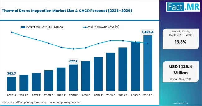
Thermal Drone Inspection Market Value Analysis | Source: Fact.MR
What are the defining numbers behind Thermal Drone Inspection Market growth?
An absolute opportunity of USD 1018.1 million is expected between 2026 and 2036. Utility asset inspection, renewable-energy monitoring, public-safety deployment and the shift toward repeatable thermal records support demand across the forecast period.
- Demand Drivers in the Market
- Utilities are expanding thermal inspection of solar fields, substations and long power corridors because abnormal heat can indicate electrical faults before service loss. Outsourced commercial drone services reduce the need for each asset owner to maintain a dedicated pilot, aircraft and image-review team.
- Inspection work is moving away from some manual access tasks where technicians would otherwise work at height or near energized equipment. This supports aerial inspection workflows that combine remote capture with a documented fault record for maintenance planning.
- Renewable capacity additions widen the asset base that requires periodic heat checks. Solar modules, electrical connections and wind-power components create recurring inspection points, while wind turbine inspection adds another difficult-access use case for thermal and visual payloads.
- Industrial plants use thermal drones to identify overheating equipment, insulation loss and electrical anomalies without stopping every asset for close manual inspection. The same operating logic supports the wider industrial drone inspection market, where thermal, visual and LiDAR data are increasingly combined in one maintenance workflow.
- Public-safety agencies use thermal imaging during fire, search-and-rescue and disaster-response work because heat signatures remain visible when smoke, darkness or unsafe structures limit direct access. Broader professional drone services adoption is therefore increasing demand for thermal-capable platforms, trained operators and standardized data handling.
- Key Segments Analyzed
- Fixed Wing accounts for 41.5% of Product Type in 2026. Longer endurance supports transmission, pipeline and large-site routes where repeated battery stops would reduce inspection productivity.
- Consumer and Civil represents 48.6% of Drone Type in 2026, reflecting use by public-safety teams, municipalities and smaller inspection contractors that need portable thermal capability.
- Energy and Utilities holds 29.8% of End User in 2026 as grid infrastructure and renewable assets require recurring thermal checks for hot joints, panel faults and abnormal equipment temperatures.
- Thermal Camera accounts for 39.6% of Payload in 2026 because heat imaging is the core data layer used to identify temperature anomalies during inspection missions.
- Semi-autonomous Flight represents 41.2% of Operation Mode in 2026, supported by preset routes that improve repeatability while keeping a pilot in supervisory control.
- Third-party Services hold 46.7% of Service Model in 2026 because many asset owners prefer to buy qualified flight operations and interpreted inspection reports rather than maintain an internal drone program.
- Analyst Opinion at Fact.MR
- “Thermal drone inspection is becoming a repeatable maintenance tool rather than a one-time aerial exercise. Utilities and industrial operators need consistent heat records that allow the same asset to be compared across inspection cycles. Public-safety users place more weight on rapid deployment and dependable thermal visibility. Suppliers that combine stable flight, radiometric data quality and usable reporting are better aligned with recurring inspection contracts through 2036.”
- Shambhu Nath Jha, Senior Consultant, Fact.MR
- Strategic Implications
- Platform suppliers should pair thermal payloads with stable flight control and clear radiometric workflows so temperature anomalies can be compared across repeat missions.
- Service providers should structure contracts around asset coverage, inspection frequency and report quality rather than flight time alone.
- Utility-focused offerings should support preset routes and repeatable capture around substations, solar arrays and long linear assets.
- Public-safety configurations need rapid deployment, low-light operation and clear thermal interpretation when crews are working around fire, smoke or unstable structures.
- Analytics providers should make thermal findings easy to export into maintenance systems so detected hot spots become repair actions rather than isolated image files.
How does the Thermal Drone Inspection Market break down by segment?
The market is segmented by Product Type, Drone Type, End User, Payload, Operation Mode and Service Model.
Why does Fixed Wing lead Product Type?
Fixed Wing is projected to account for a 45.9% share of Product Type in 2026.
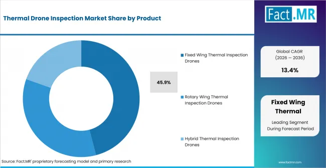
Thermal Drone Inspection Market Analysis By Product | Source: Fact.MR
Fixed-wing drones are suited to long inspection routes where coverage per flight matters. Transmission corridors, pipelines, large solar sites and distributed infrastructure can require inspection across several kilometers, making endurance and route efficiency important purchasing criteria.
Delair supports long-range infrastructure work and offers radiometric thermal payload configurations for hot-spot detection, solar-panel inspection and power-line checks. The operational benefit is reduced launch frequency when the mission covers a broad asset footprint.
Why does Consumer and Civil lead Drone Type?
Consumer and Civil is projected to account for a 55.6% share of Drone Type in 2026.
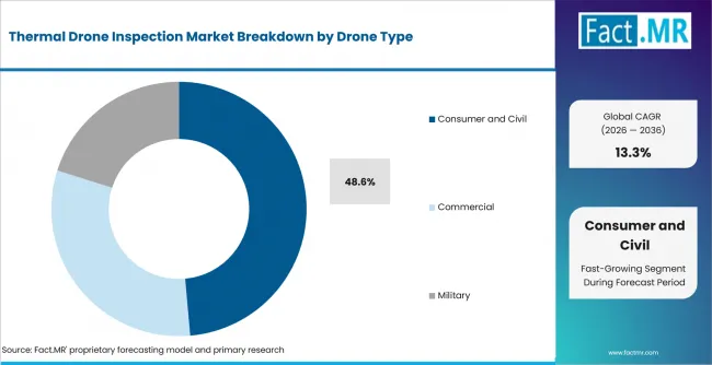
Thermal Drone Inspection Market Analysis By Drone Type | Source: Fact.MR
Civil agencies and smaller inspection teams often need portable systems that can be deployed quickly for building checks, emergency response and localized asset inspection. Lower logistics requirements make these platforms practical where mission scale does not justify a heavier industrial aircraft.
The segment also benefits from the availability of compact thermal platforms that combine visible, zoom and infrared sensors. This allows one aircraft to support routine inspection and public-safety work without separate capture systems.
Why do Energy and Utilities lead End User?
Energy and Utilities are projected to account for a 25.3% share of End User in 2026.
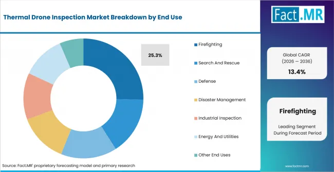
Thermal Drone Inspection Market Analysis By End Use | Source: Fact.MR
Power networks and renewable sites contain many temperature-sensitive failure points. Loose electrical connections, damaged modules, overheating components and insulation problems can create abnormal heat patterns before the asset fails completely.
DJI Enterprise positions the Matrice 4T for automated photovoltaic inspection using visible and thermal imaging, while Delair supports power-line and solar thermal mapping. Asset owners therefore buy thermal drone inspection as part of preventive maintenance rather than waiting for a visible fault or outage.
Why does Thermal Camera lead Payload?
Thermal Camera is projected to account for a 39.6% share of Payload in 2026.
The thermal camera produces the primary inspection evidence by showing relative and, in radiometric systems, measurable temperature differences across the asset. This makes it directly useful for electrical hot spots, heat loss, solar-module anomalies and fire-scene assessment.
Current enterprise platforms combine thermal imaging with visible cameras and zoom capability. DJI Matrice 4T and Autel EVO Max 4T both use 640 × 512 thermal imagers, while Skydio X10 offers a radiometric Teledyne FLIR Boson+ module. Buyers can therefore pair heat data with visual confirmation in the same mission.
Why does Semi-autonomous Flight lead Operation Mode?
Semi-autonomous Flight is projected to account for a 41.2% share of Operation Mode in 2026.
Preset paths help inspection teams repeat the same route, camera angle and asset sequence while retaining pilot supervision. This is useful for solar fields and grid assets where year-to-year comparison depends on consistent image capture.
The model also fits current regulatory practice better than fully unattended operation in many environments. Operators can automate routine route execution while retaining responsibility for changing weather, airspace conditions and unexpected obstacles.
Why do Third-party Services lead Service Model?
Third-party Services are projected to account for a 46.7% share of Service Model in 2026.
Thermal inspection requires more than an aircraft. Asset owners need trained pilots, suitable permissions, calibrated payloads, flight planning and interpretation of heat patterns. Outsourcing allows them to buy the finished inspection result without maintaining each capability internally.
The model is particularly practical for organizations with periodic rather than daily inspection demand. Providers can spread aircraft, battery, software and pilot costs across several clients while delivering standardized reports and faster scheduling.
What is accelerating Thermal Drone Inspection Market adoption, and what is holding it back?
Adoption is being supported by utility asset monitoring, renewable-energy growth, public-safety use and the need to reduce manual access to difficult inspection points. Growth is moderated by weather limits, airspace requirements, radiometric payload cost, battery replacement and the need to convert thermal imagery into reliable maintenance decisions.
Drivers Impact Analysis
| Factor | (~) % Impact on CAGR | Geographic Relevance | Impact Timeline |
|---|---|---|---|
| Utility asset monitoring and repeat thermal inspections | +1.3% | Global | Short term (≤ 2 years) |
| Renewable-energy site inspection requirements | +1.1% | Global | Short term (≤ 2 years) |
| Public-safety and infrastructure inspection deployment | +0.8% | Global | Medium term (2-4 years) |
| Reduced manual access to difficult or hazardous inspection points | +0.7% | Global | Medium term (2-4 years) |
Source: Fact.MR analysis. Updated Sep 3, 2026
Opportunity Impact Analysis
| Factor | (~) % Impact on CAGR | Geographic Relevance | Impact Timeline |
|---|---|---|---|
| Autonomous route execution for repeat inspections | +0.9% | Global | Medium term (2-4 years) |
| Radiometric analytics and automated fault ranking | +0.8% | Global | Medium term (2-4 years) |
| Integration of thermal and visual sensor payloads | +0.6% | Global | Medium term (2-4 years) |
| Recurring inspection contracts linked with maintenance records | +0.5% | Global | Long term (≥ 4 years) |
Source: Fact.MR analysis. Updated Sep 3, 2026
Restraints Impact Analysis
| Factor | (~) % Impact on CAGR | Geographic Relevance | Impact Timeline |
|---|---|---|---|
| High radiometric thermal payload and equipment cost | -0.9% | Global | Short term (≤ 2 years) |
| Battery endurance and limited inspection flight windows | -0.7% | Global | Short term (≤ 2 years) |
| Weather-dependent drone operations | -0.6% | Global | Short term (≤ 2 years) |
| Airspace approvals and aviation compliance requirements | -0.5% | Global | Medium term (2-4 years) |
| Competition from pilot labor and alternative inspection methods | -0.4% | Global | Medium term (2-4 years) |
Source: Fact.MR analysis. Updated Sep 3, 2026
Which countries are scaling the Thermal Drone Inspection Market through 2036?
- China is expanding thermal inspection demand as solar and grid infrastructure add longer routes and more electrical assets that require repeat heat checks. Renewable additions create a broad inspection base for utilities and contractors.
- India is adding inspection demand through utility-scale solar growth and expanding power infrastructure. Large panel fields create repeatable use cases for module and connection-level thermal screening.
- The United States combines utility maintenance, wildfire response and commercial drone operations. Thermal inspection is used across power assets and public-safety workflows where reducing worker exposure can justify aerial deployment.
- South Korea is widening field deployment through drone test zones and energy infrastructure projects. Regulatory test environments make it easier to validate inspection routes before moving them into routine commercial operations.
- Germany has a substantial solar and industrial asset base that supports fault detection in panels, inverters and electrical equipment. Repeat inspection demand rises as distributed energy assets expand.
- The United Kingdom is developing a broader compliant drone-user base while utilities and asset owners continue to use aerial inspection for energy and building applications. Operator education and aviation compliance remain important purchasing conditions.
- Japan combines renewable expansion with older power infrastructure that requires condition monitoring. Thermal inspection offers a way to screen geographically dispersed assets before dispatching maintenance teams.
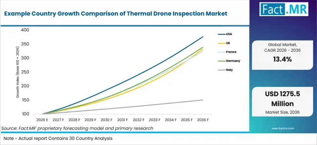
Example Country Growth Comparison Of Thermal Drone Inspection Market | Source: Fact.MR
| Country | CAGR (2026-2036) |
|---|---|
| China | 15.3% |
| India | 14.7% |
| United States | 14.2% |
| South Korea | 13.6% |
| Germany | 13.0% |
| United Kingdom | 12.8% |
| Japan | 11.8% |
Source: Fact.MR analysis. Updated Sep 3, 2026
What is driving China's growth through 2036?
China is forecast to expand at a 15.3% CAGR from 2026 to 2036.
Renewable-energy deployment is increasing the number of assets that require inspection. Chinese government reporting cited more than 430 GW of combined wind and solar additions in 2025, creating more panels, electrical connections and grid interfaces that can be screened with thermal imaging.
Long inspection routes favor providers that can standardize data collection across large sites. The commercial opportunity extends from flight services to radiometric analysis and maintenance records that help utilities prioritize field work.
What is driving India's growth through 2036?
India is forecast to expand at a 14.7% CAGR from 2026 to 2036.
India crossed 150.26 GW of cumulative installed solar capacity by March 2026 according to the Ministry of New and Renewable Energy. Utility-scale solar fields create a direct thermal-inspection workload because defective modules, connectors and electrical components can appear as abnormal heat signatures.
Service providers that can cover large sites quickly and deliver fault-location records can reduce the need for manual module-by-module screening. This supports repeat contracts as the operating solar base expands.
What is driving the United States' growth through 2036?
The United States is forecast to expand at a 14.2% CAGR from 2026 to 2036.
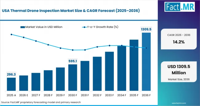
Thermal Drone Inspection Market Country Value Analysis | Source: Fact.MR
Demand comes from both infrastructure inspection and public safety. Utilities use thermal drones around power assets, while fire and emergency teams use heat imaging to locate hot zones or people when direct access is unsafe.
FAA work on beyond-visual-line-of-sight operations is also relevant to repeat route economics. More scalable authorization frameworks can reduce operating friction for linear-asset inspection, although pilots and service firms must continue to meet applicable flight requirements.
What is driving South Korea's growth through 2036?
South Korea is forecast to expand at a 13.6% CAGR from 2026 to 2036.
The Ministry of Land, Infrastructure and Transport expanded Drone Special Free Zones to 67 locations in 2025. These zones give companies and public agencies more room to test new flight and inspection approaches under controlled regulatory conditions.
Energy and industrial assets provide the commercial application base. Once thermal routes are validated, service providers can move toward repeat inspection schedules for electrical systems, facilities and renewable infrastructure.
What is driving Germany's growth through 2036?
Germany is forecast to expand at a 13.0% CAGR from 2026 to 2036.
Solar capacity reached about 117 GW at the end of 2025 according to the Bundesnetzagentur. A field base of that scale creates recurring requirements for inspection of modules, inverters and electrical connections, particularly where operators need to identify faults before output is materially affected.
Industrial users add another demand layer through electrical and mechanical heat checks. Thermal drone services are most useful when asset location, height or site layout makes routine close inspection slower or more disruptive.
What is driving the United Kingdom's growth through 2036?
The United Kingdom is forecast to expand at a 12.8% CAGR from 2026 to 2036.
The UK Civil Aviation Authority introduced updated drone-user requirements from January 2026 and highlighted the need for a larger group of users to understand the new rules. A clearer compliance base supports professional inspection providers that need repeat access to client sites.
Energy assets, commercial buildings and public-safety applications create the use cases. Providers compete on safe operations and report consistency as much as on the thermal camera itself.
What is driving Japan's growth through 2036?
Japan is forecast to expand at an 11.8% CAGR from 2026 to 2036.
Renewable development and existing power infrastructure sustain thermal-inspection demand. METI set a 1.2 GW onshore wind bidding-capacity trigger for FY2025, adding to an asset base that requires periodic inspection over long operating lives.
Thermal drones can reduce initial field screening time at distributed sites by identifying temperature anomalies before crews conduct closer physical inspection. This supports demand where access conditions or asset dispersion make manual checks expensive.
Who Leads the Thermal Drone Inspection Market?
Key players in the Thermal Drone Inspection Market include DJI Enterprise, Teledyne FLIR, Autel Robotics, Skydio, Parrot, Delair and Percepto.
Competition is shaped by thermal-data quality, flight reliability, autonomy, payload flexibility and the ability to convert images into a repeatable inspection record. DJI Enterprise and Autel Robotics offer current enterprise platforms with integrated thermal cameras, while Skydio combines autonomous navigation with a radiometric Teledyne FLIR Boson+ sensor on its X10 platform.
Teledyne FLIR remains relevant through thermal imaging modules and partner integrations rather than relying only on its own aircraft. Its SIRAS drone ended sales in August 2025, but FLIR thermal cores continue to be integrated into commercial UAS platforms. Parrot supports compact secure thermal operations through ANAFI USA, while Delair addresses long-range infrastructure routes and radiometric thermal mapping.
Percepto competes through autonomous site inspection and remote operations. Its AirMax portfolio supports visual and thermal inspection, making it relevant to facilities that want scheduled data capture with centralized analysis rather than pilot-led missions at every inspection point.
Which companies are the key providers?
Key providers include DJI Enterprise, Teledyne FLIR, Autel Robotics, Skydio, Parrot, Delair and Percepto.
- DJI Enterprise
- Teledyne FLIR
- Autel Robotics
- Skydio
- Parrot
- Delair
- Percepto
Bibliography
- Federal Aviation Administration. (2025). Beyond Visual Line of Sight (BVLOS) Fact Sheet. U.S. Department of Transportation.
- International Energy Agency. (2025). Renewables 2025: Renewable Electricity. IEA.
- State Council of the People’s Republic of China. (2026). Renewables Account for Over 60 Percent of China’s Power Capacity in 2025. Government of China.
- Ministry of New and Renewable Energy. (2026). India Ranks Third Globally in Renewable Energy Installed Capacity. Government of India.
- UK Civil Aviation Authority. (2025). Regulator Calls on New and Existing Drone Users to Learn New Rules Before Taking Off. UK Civil Aviation Authority.
- Bundesnetzagentur. (2026). Growth in Renewable Energy in 2025. Federal Network Agency, Germany.
- Ministry of Economy, Trade and Industry, Japan. (2025). Renewable Energy Purchase Prices and FIT/FIP Details for FY2025. Government of Japan.
- Ministry of Land, Infrastructure and Transport, Republic of Korea. (2025). Expansion of Drone Special Free Zones Nationwide. Government of the Republic of Korea.
- DJI Enterprise. (2026). Matrice 4 Series Specifications and Photovoltaic Power Plant Inspection Workflow. DJI.
- Autel Robotics. (2026). EVO Max 4T Enterprise Drone. Autel Robotics.
- Skydio. (2026). Skydio X10 Platform and Thermal Sensor Specifications. Skydio.
- Parrot. (2026). ANAFI USA GOV User Guide: Thermal Imaging. Parrot.
- Teledyne FLIR. (2026). Thermal Imaging for Unmanned Aircraft Systems and Thermal by FLIR Integrations. Teledyne FLIR.
- Delair. (2026). Linear Infrastructure Solutions and Radiometric Thermal Imaging Payloads. Delair.
- Percepto. (2026). Autonomous Drone Technology and Industrial Inspection Solutions. Percepto.
This Report Answers
- What is the Thermal Drone Inspection Market value in 2026 and what value is forecast for 2036?
- Why does Fixed Wing hold the leading Product Type share?
- Why do Energy and Utilities account for a leading share of thermal inspection demand?
- How do thermal cameras, radiometric sensors and multi-sensor payloads change inspection workflows?
- Why does Semi-autonomous Flight hold the leading Operation Mode share?
- Why do Third-party Services account for a substantial part of the Service Model?
- How do growth conditions differ across China, India, the United States, South Korea, Germany, the United Kingdom and Japan?
- Which companies supply thermal-capable drone platforms, sensing technology and autonomous inspection systems?
What does the Thermal Drone Inspection Market cover?
The Thermal Drone Inspection Market covers drone platforms, thermal inspection services and associated data workflows used to detect heat patterns across power assets, industrial facilities, buildings and public-safety sites. Revenue is counted when thermal imaging is a direct part of the commercial drone system or inspection service.
Applications include electrical fault detection, solar-module inspection, industrial condition checks, building heat-loss assessment, firefighting, search and rescue, disaster management and other asset inspections represented by the End User categories.
What is included in the scope?
Included Product Type categories are Fixed Wing, Rotary Wing and Hybrid. Drone Type includes Consumer and Civil, Commercial and Military platforms when they are used for the covered thermal-inspection functions.
End User includes Firefighting, Search and Rescue, Defense, Disaster Management, Industrial Inspection, Energy and Utilities, and Others. Payload includes Thermal Camera, Multi-sensor Payload, Radiometric Sensor, Zoom Lens and Gas Sensor. Operation Mode includes Manual Flight, Semi-autonomous Flight and Autonomous Flight. Service Model includes In-house Inspection, Third-party Services, Software Analytics and Training.
What is excluded from the scope?
The scope excludes drones used only for photography, entertainment, agricultural spraying, parcel delivery or general mapping without thermal inspection output. Standalone thermal cameras are excluded when they are sold without drone integration or inspection-service linkage.
General military surveillance, crewed-aircraft thermography and downstream repair work are outside the market unless thermal drone inspection itself is the commercial service being purchased. Conventional visual inspection without thermal output is treated as an adjacent market.
How Was the Analysis Built?
The analysis combines demand from utility assets, industrial facilities, buildings and public-safety operations with the thermal-capable drone platforms and service models used to inspect them.
- Primary Research: Interviews with utility inspection managers, industrial maintenance teams, public-safety drone program leads, commercial drone service providers, thermal-payload suppliers and platform vendors assess inspection frequency, route planning, payload selection, pricing and data-use requirements.
- Desk Research: The review covers aviation rules, renewable-energy deployment, government drone test programs, enterprise drone specifications, thermal-camera capabilities, infrastructure inspection practices and current supplier portfolios.
- Market Sizing and Forecasting: Estimates combine inspection volume, platform deployment, service pricing, Product Type, Drone Type, End User, Payload, Operation Mode and Service Model mix. Country assumptions reflect renewable asset growth, infrastructure demand and commercial drone operating conditions.
- Data Validation and Update Cycle: Findings are cross-checked against current drone specifications, thermal-payload documentation, public energy data, aviation guidance and active company portfolios. Updates account for platform launches, regulatory changes, renewable additions and inspection-service adoption.
Segmentation
What is the report's scope and coverage?
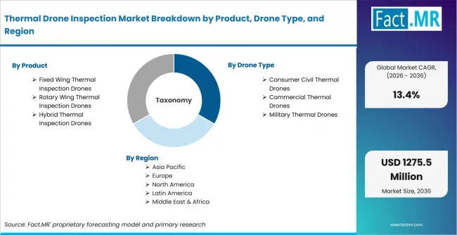
Thermal Drone Inspection Market Breakdown By Product, Drone Type, And Region | Source: Fact.MR
| Attribute | Details |
|---|---|
| Quantitative Units | USD million |
| Market Definition | Drone platforms and services using thermal imaging for aerial inspection of power, industrial, building and public-safety assets |
| Segments Covered | Product Type; Drone Type; End User; Payload; Operation Mode; Service Model |
| Regions Covered | North America; Europe; East Asia; South Asia and Pacific; Latin America; Middle East and Africa |
| Countries Covered | China; India; United States; South Korea; Germany; United Kingdom; Japan |
| Key Companies Profiled | DJI Enterprise; Teledyne FLIR; Autel Robotics; Skydio; Parrot; Delair; Percepto |
| Forecast Period | 2026 to 2036 |
| Base Year | 2025 |
| Market Value, 2026 | USD 362.7 million |
| Market Value, 2036 | USD 1,275.5 million |
| CAGR, 2026-2036 | 13.4% |
| Absolute Opportunity | USD 1,018.1 million |
| Approach | Hybrid top-down and bottom-up model using platform deployment, thermal payload mix, inspection volume, service pricing, asset coverage and country demand |
Source: Fact.MR analysis. Updated Sep 3, 2026
How is the market segmented?
-
By Product Type
- Fixed Wing Thermal Inspection Drones
- Long Range Inspection Drones
- High Altitude Inspection Drones
- Rotary Wing Thermal Inspection Drones
- Single Rotor Thermal Drones
- Multi Rotor Thermal Drones
- Hybrid Thermal Inspection Drones
- VTOL Hybrid Drones
- Fixed Wing Hybrid Drones
- Fixed Wing Thermal Inspection Drones
-
By Drone Type
- Consumer Civil Thermal Drones
- Recreational Thermal Drones
- Public Safety Thermal Drones
- Commercial Thermal Drones
- Industrial Inspection Drones
- Enterprise Thermal Drones
- Military Thermal Drones
- Tactical Thermal Drones
- Defense Intelligence Drones
- Consumer Civil Thermal Drones
-
By End User
- Firefighting
- Forest Fire Monitoring
- Urban Fire Assessment
- Search And Rescue
- Missing Person Detection
- Disaster Recovery Search
- Defense
- Border Surveillance
- Tactical Operations
- Disaster Management
- Flood Monitoring
- Earthquake And Landslide Assessment
- Industrial Inspection
- Manufacturing Facility Inspection
- Infrastructure Inspection
- Energy And Utilities
- Power Grid Inspection
- Renewable Energy Inspection
- Other End Uses
- Agricultural Monitoring
- Mining And Quarry Inspection
- Firefighting
-
By Application
- Energy Infrastructure Inspection
- Power Transmission Lines
- Oil & Gas Infrastructure
- Construction Site Monitoring
- Building Envelope Inspection
- Large Infrastructure Projects
- Renewable Energy Inspection
- Solar Farm Inspection
- Wind Turbine Inspection
- Industrial Facility Inspection
- Manufacturing Plant Monitoring
- Warehouse Safety Inspection
- Energy Infrastructure Inspection
-
By Region
- North America
- Latin America
- Western Europe
- Eastern Europe
- East Asia
- South Asia and Pacific
- Middle East & Africa
Frequently Asked Questions
What is the Thermal Drone Inspection Market value in 2026?
At what CAGR is the Thermal Drone Inspection Market projected to grow?
What is the projected Thermal Drone Inspection Market value by 2036?
Which Product Type leads the market?
Which Drone Type leads the market?
Which End User leads the market?
Which Payload leads the market?
Which Operation Mode leads the market?
Which Service Model leads the market?
Which country records the leading listed CAGR?
What is the primary driver in this market?
What is the main restraint?
Which companies are active in the Thermal Drone Inspection Market?
Who worked on this report


Preview the report firsthand - request a free sample
Free SampleGet the brochure for pricing and purchase details
Download PDF