- Market Value (2025): USD 23.8 Bn
- Estimated Value (2026): USD 27.7 Bn
- Forecast Value (2036): USD 128.7 Bn
- CAGR (2026-2036): 16.6%
What is the Commercial Drone Services Market forecast to be worth by 2036?
USD 27.7 billion in 2026 to USD 128.7 billion by 2036 at 16.6% CAGR.
- The Commercial Drone Services Market crossed a valuation of USD 23.8 billion in 2025.
- Demand is projected to increase from USD 27.7 billion in 2026 to USD 128.7 billion by 2036.
- The market is forecast to record a 16.6% CAGR from 2026 to 2036 as construction firms, energy operators and delivery networks use specialist providers for compliant aerial work.
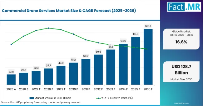
Commercial Drone Services Market Value Analysis | Source: Fact.MR
What are the defining numbers behind Commercial Drone Services Market growth?
USD 101.0 billion absolute opportunity by 2036, led by mapping and surveying, energy and construction infrastructure.
- Demand Drivers in the Market
- Construction managers need aerial site records that shorten inspection cycles and help project teams compare progress against design plans.
- Energy operators use drone crews for remote inspection when lines, solar assets and oil and gas facilities are costly to survey from the ground.
- Retail and logistics teams are testing delivery networks as aircraft routing, store integration and customer eligibility become service-led tasks.
- Public agencies need repeatable emergency response and infrastructure monitoring capacity, supported by pilots who understand route documentation.
- Agriculture service firms use spraying, seeding and field monitoring where terrain or crop timing makes ground work less efficient.
- Key Segments Analyzed
- By Service Type: Mapping and Surveying is expected to hold 32.60% share in 2026 since aerial data supports repeat work in construction, land management and utility planning.
- By End Use: Energy is projected to account for 26.20% share in 2026, supported by inspection needs across renewable energy and utility infrastructure.
- By Product: Aerial Imaging Services are anticipated to capture 46.80% share in 2026, attributable to demand for photogrammetry and inspection imagery.
- By Application: Construction & Infrastructure is estimated to represent 61.30% share in 2026 oWing Aviation LLC to site monitoring and asset documentation requirements.
- Analyst Opinion at Fact.MR
- Shambhu Nath Jha, Principal Consultant at Fact.MR, states, "Commercial drone services are gaining budget because the customer is buying a verified flight outcome instead of a basic aircraft hour. Demand is expected to favor providers that combine airspace compliance, trained pilots and usable data outputs. Service depth is becoming the difference between one-off jobs and recurring inspection contracts."
- Strategic Implications
- Service providers should document flight approvals, pilot credentials and data accuracy so clients can treat aerial outputs as audit-ready records.
- Construction-focused operators should connect mapping, site monitoring and reporting tools to project management workflows.
- Energy inspection teams should pair thermal imagery with asset-specific reporting so field crews can prioritize repairs.
- Delivery specialists should build local operating playbooks around noise, safe landing zones and customer order limits.
USA is projected to record 9.2% CAGR through 2036, led by BVLOS rulemaking and store-linked delivery networks. South Korea is anticipated to post 8.5% CAGR as special zones widen local service testing. Germany is forecast to advance at 7.8% CAGR, supported by renewable-asset inspection. Japan is estimated to hold 7.4% CAGR due to registered aircraft operations and smart-agriculture routes. The UK is expected to reach 7.3% CAGR as rule changes and government funding support drone integration. France is projected to record 7.0% CAGR as agricultural permissions and solar assets create service demand. Italy is forecast to post 6.6% CAGR as energy infrastructure and farm services shape adoption.
How does the Commercial Drone Services Market break down by segment?
Mapping and Surveying leads Service Type at 32.60%; Construction & Infrastructure leads Application at 61.30%.
Which Service Type dominates?
Mapping and Surveying holds 32.6% share in 2026.
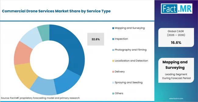
Commercial Drone Services Market Analysis By Service Type | Source: Fact.MR
Mapping and surveying leads because service buyers need measured outputs that replace repeated ground walks or helicopter flights. Aerial mapping turns flight activity into orthomosaics, point clouds and progress records that teams can use across planning and field decisions.
The segment also benefits from the wider use of photogrammetry in construction and infrastructure work. Service providers that combine pilot compliance with clean data delivery gain repeat assignments as clients standardize survey quality across multiple sites.
What leads the End Use segment?
Energy accounts for 26.2% share in 2026.
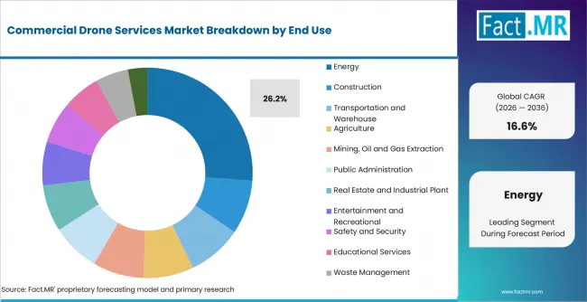
Commercial Drone Services Market Analysis By End Use | Source: Fact.MR
Energy leads because assets are widely distributed and often hard to reach. Utility infrastructure, renewable plants and oil and gas facilities require inspection routes that reduce site access time and protect workers from height or confined-area exposure.
Thermal and visual inspection services are relevant where operators need to identify damaged panels, overheating components or corrosion before outages occur. Bundesnetzagentur reported in January 2026 that Germany added 16.4 GW of solar capacity in 2025.
How does Product shape demand?
Aerial Imaging Services capture 46.8% share in 2026.
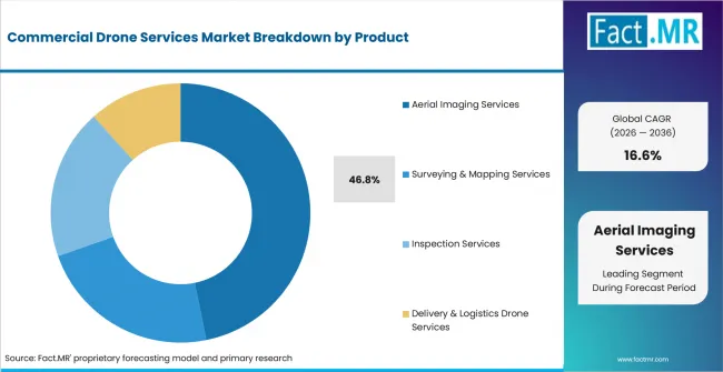
Commercial Drone Services Market Analysis By Product | Source: Fact.MR
Aerial imaging services lead because many clients start with a clear need for visual proof. Photogrammetry, cinematic filming, land survey imagery and geospatial mapping depend on stable capture, repeat routes and standardized file delivery.
What supports Construction & Infrastructure within Application?
Construction & Infrastructure represents 61.3% share in 2026.
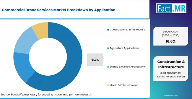
Commercial Drone Services Market Analysis By Application | Source: Fact.MR
Construction and infrastructure hold the main application share because drone services document site status faster than many manual methods. Project managers use aerial records to track earthwork, roof progress, equipment movement and safety conditions during active work.
The U.S. Census Bureau reported on August 3, 2026 that construction spending during June 2026 was estimated at a seasonally adjusted annual rate of USD 2,166.5 billion.
What is accelerating Commercial Drone Services Market adoption, and what is holding it back?
Adoption is rising through BVLOS rulemaking, infrastructure inspection and delivery pilots. Constraints come from safety approval, flight restrictions and weather-sensitive operations.
Drivers Impact Analysis
| DRIVER | (~) % IMPACT ON CAGR | GEOGRAPHIC RELEVANCE | IMPACT TIMELINE |
|---|---|---|---|
| BVLOS rulemaking for commercial routes | +1.7% | USA, UK, Japan | Short term (<= 2 years) |
| Infrastructure and energy inspection demand | +1.5% | North America, Europe, East Asia | Medium term (2-4 years) |
| Retail and medical delivery service trials | +1.2% | USA, UK, Japan | Medium term (2-4 years) |
| Survey data needs in construction projects | +1.0% | Global | Long term (>= 4 years) |
- BVLOS rulemaking for commercial routes: Clearer rules for beyond-visual-line-of-sight operations can support route-based drone services by defining requirements around authorizations, separation, security, reporting and record keeping.
- Infrastructure and energy inspection demand: Asset owners need recurring inspection of power lines, solar panels, towers and remote facilities. Drone services can reduce field exposure, improve inspection frequency and create digital records for maintenance planning.
- Retail and medical delivery service trials: Delivery providers continue testing local drone networks where short flight distances and lightweight packages align with aircraft payload capabilities. These trials can support wider adoption across retail, healthcare and last-mile logistics applications.
- Survey data needs in construction projects: Contractors use drone-based mapping and site monitoring to compare project progress with schedules, draWing Aviation LLCs and safety plans. Regular aerial data can improve visibility across large sites and support faster project documentation and decision-making.
Opportunity Impact Analysis
| OPPORTUNITY | (~) % IMPACT ON CAGR | GEOGRAPHIC RELEVANCE | IMPACT TIMELINE |
|---|---|---|---|
| Managed aerial-data packages for contractors | +1.3% | USA, Europe, East Asia | Short term (<= 2 years) |
| Drone inspection for renewable assets | +1.1% | Europe, Japan, South Korea | Medium term (2-4 years) |
| Indoor and confined-area inspection services | +0.8% | Global | Medium term (2-4 years) |
- Managed aerial-data packages for contractors: Drone service providers can bundle survey outputs, progress records, inspection notes and visual documentation rather than charging only for flight time. This can create more recurring value for contractors managing complex construction and infrastructure projects.
- Drone inspection for renewable assets: Expanding solar and wind infrastructure creates recurring inspection needs for thermal checks, vegetation review, surface assessment and component monitoring. Drone services can support faster inspection cycles while reducing reliance on manual access to large or remote assets.
- Indoor and confined-area inspection services: Specialized drones designed for indoor and confined environments can support inspection of facilities where GPS access, visibility or human entry is limited. These systems can extend drone-service opportunities across industrial plants, warehouses, tunnels and other enclosed infrastructure.
Restraints Impact Analysis
| RESTRAINT | (~) % IMPACT ON CAGR | GEOGRAPHIC RELEVANCE | IMPACT TIMELINE |
|---|---|---|---|
| Safety approvals for routine BVLOS work | -0.7% | USA, Europe, Japan | Short term (<= 2 years) |
| Training and operator identification requirements | -0.5% | UK, Japan, Italy | Medium term (2-4 years) |
| Weather, payload and endurance limits | -0.4% | Global | Long term (>= 4 years) |
- Safety approvals for routine BVLOS work: Operators need documented procedures covering separation, aircraft performance, route responsibility and operational risk before routine beyond-visual-line-of-sight services can scale across commercial applications.
- Training and operator identification requirements: Training, registration and operator-identification requirements can add compliance steps before drone services expand. These obligations increase the importance of clear operating procedures, user education and regulatory readiness for service providers.
- Weather, payload and endurance limits: Wind, rain, battery capacity and payload weight continue to influence where drones can replace or complement ground-based work. Mission planning must balance aircraft capability, environmental conditions and route requirements to maintain reliable service delivery.
Which countries are scaling the Commercial Drone Services Market through 2036?
- The country comparison spans 2.6 percentage points, from 9.2% CAGR in the USA to 6.6% CAGR in Italy.
- USA remains ahead through BVLOS rulemaking and commercial route testing.
- South Korea follows as test zones, city projects and industrial groups create local service channels.
- Germany benefits from renewable-energy inspection requirements and digital infrastructure work.
- Japan develops through registered operations, route guidance and government-backed smart agriculture plans.
- The UK advances through aviation funding, updated operator rules and inspection demand across assets.
- France and Italy close the range through agriculture, infrastructure and regulated operating frameworks.
Comparable CAGRs create different entry conditions because commercial drone work depends on local airspace rules, client density and the value of repeat data. Full report coverage includes North America, Latin America, Western Europe, Eastern Europe, East Asia, South Asia & Pacific, Middle East & Africa.
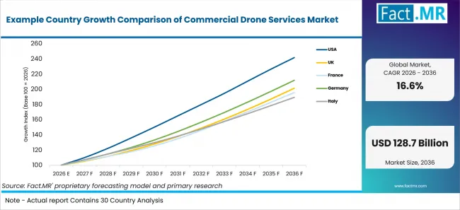
Example Country Growth Comparison Of Commercial Drone Services Market | Source: Fact.MR
| Country | CAGR (2026-2036) |
|---|---|
| USA | 9.2% |
| South Korea | 8.5% |
| Germany | 7.8% |
| Japan | 7.4% |
| UK | 7.3% |
| France | 7.0% |
| Italy | 6.6% |
What supports USA adoption?
9.2% CAGR, supported by BVLOS rulemaking and commercial route testing.
USA adoption is shaped by a large commercial flight base and active rulemaking. FAA proposed a BVLOS rule in August 2025 that covers operations, aircraft manufacturing, separation, authorizations, security, reporting and record keeping. The proposal gives service providers a clearer path for long-distance inspection, delivery, farming and emergency-response routes.
How is South Korea scaling demand?
8.5% CAGR, backed by special zones and local demonstration programs.
MOLIT reported on July 31, 2025 that Drone Special Free Zones had expanded to 67 zones across 32 local governments. MOLIT said the zones simplify or exempt six drone-related regulations and enable real-world service demonstrations, shortening test-flight and service-demonstration timelines by approximately three to five months or more.
What supports Germany’s adoption?
7.8% CAGR, supported by renewable inspection and infrastructure work.
Bundesnetzagentur reported in January 2026 that Germany’s installed solar capacity reached 117 GW at the end of 2025 after 16.4 GW of additions during the year. The larger installed solar asset base as context for inspection-service opportunities.
How does Japan perform?
7.4% CAGR, led by registered aircraft operations and smart-agriculture routes.
Japan’s demand develops around formal registration and farm-service modernization. MLIT states that unmanned aircraft weighing 100 g or more that fly outdoors must be registered under Japan’s Civil Aeronautics Act and, subject to specified exemptions, must be equipped with a Remote ID function. MAFF certified development-and-supply implementation plans submitted by nine businesses on April 25, 2025; the batch included systems linking sensing equipment with spraying drones and development of a pesticide-spraying drone together with a nationwide spraying service.
What supports the United Kingdom’s growth?
7.3% CAGR, backed by aviation funding and rule-change awareness.
The UK combines government funding with rule-change awareness. The Department for Transport announced over GBP 20 million in April 2025 to support drones and flying taxis. Funded trials help service providers test delivery, infrastructure inspection and airspace integration with clearer links to commercial use.
How is France developing demand?
7.0% CAGR, shaped by agriculture permissions and solar inspection needs.
France’s Ministry of Agriculture reported in June 2026 that approximately 150 crop-protection products were authorized for drone application under the new framework. France’s official solar dashboard reported 31.3 GW of installed photovoltaic capacity at the end of 2025.
How does Italy scale commercial use?
6.6% CAGR, supported by energy infrastructure and farm-service demand.
Terna reported on January 21, 2026, that Italian electricity consumption reached 311.3 TWh in 2025. Istat reported on June 12, 2026, that Italy’s crop output value reached EUR 37.5 billion in 2025.
Who leads the Commercial Drone Services Market?
Competition is led by providers that combine aircraft operations, data outputs and client-specific reporting. Terra Drone, Cyberhawk, Percepto and DroneDeploy are relevant where customers need inspection, mapping and asset intelligence. Wing Aviation LLC, Amazon.com, Inc. (Prime Air), Matternet, Inc., Flytrex and Skyports Drone Services shape delivery-led service models that require route approval, fleet operations and reliable customer handoff.
Company activity reflects expanding commercial deployment models. Matternet, Inc. expanded its FAA Part 135 operating partner network in July 2026 with Beeline UAS to support U.S. delivery growth across food, retail and healthcare customers. Terra Drone launched Terra Xross 1 in January 2025 for indoor inspection applications in Japan and the United States.
Platform suppliers remain relevant when their systems support service workflows. Yamaha Motor Co., Ltd. remains visible in agricultural spraying. Delair, AeroVironment, Inc., Skydio and Percepto support enterprise inspection and data capture use cases where service providers need reliable aircraft, software and operating support.
Which companies are the key providers?
Key companies include AeroVironment, Inc.; Delair; Yamaha Motor Co., Ltd.; Terra Drone Corporation; Cyberhawk; Percepto; Matternet, Inc.; Wing Aviation LLC; Amazon.com, Inc. (Prime Air); Zipline; Flytrex; Skyports Drone Services; DroneDeploy; Rakuten Group, Inc. (Rakuten Drone).
- AeroVironment, Inc.
- Delair
- Yamaha Motor Co., Ltd.
- Terra Drone Corporation
- Cyberhawk
- Percepto
- Matternet, Inc.
- Wing Aviation LLC
- Amazon.com, Inc. (Prime Air)
- Zipline
- Flytrex
- Skyports Drone Services
- DroneDeploy
- Rakuten Group, Inc. (Rakuten Drone)
Bibliography
- Federal Aviation Administration. (2025, August 6). Beyond Visual Line of Sight (BVLOS).
- U.S. Census Bureau. (2026, August 3). Monthly construction spending, June 2026.
- Department for Transport. (2025, April 1). Over £20 million to help drones and flying taxis take to UK skies.
- UK Civil Aviation Authority. (2025, December 29). Regulator calls on new and existing drone users to learn new rules before taking off.
- Ministry of Land, Infrastructure and Transport. (2025, July 31). Lowering regulatory barriers by Drone Special Free Zones nationwide.
- Ministry of Land, Infrastructure and Transport. (2025, March 6). K-Drone to Save Lives and More.
- Bundesnetzagentur. (2026, January 8). Growth in renewable energy in 2025.
- Ministère de l’Agriculture, de l’Agro-alimentaire et de la Souveraineté alimentaire. (2026, June 10). Protection des cultures : publication des textes autorisant l'utilisation de drones pour l’application de certains produits phytopharmaceutiques.
- Service des données et études statistiques. (2026, February 27). Tableau de bord : solaire photovoltaïque - Quatrième trimestre 2025.
- Istituto Nazionale di Statistica. (2026, June 12). Economic accounts for agriculture - Year 2025.
- Terra Drone Corporation. (2025, January 31). Terra Drone launches Japan-made indoor inspection drone “Terra Xross 1” simultaneously in Japan and the US.
This Report Addresses
- The report explains where commercial drone services are used across service type, end use, product and application.
- Segment analysis identifies the leading subsegments and the operating reasons service buyers prioritize them.
- Country analysis reviews the listed markets and the policy or industry mechanisms supporting drone deployment.
- Competitive analysis reviews current providers across aerial imaging, inspection, mapping and delivery services.
- Application analysis assesses how site monitoring, energy inspection, delivery routes and agriculture workflows influence spending decisions.
What does the Commercial Drone Services Market cover?
The Commercial Drone Services Market covers outsourced drone-based work performed for business, government and institutional customers. It includes data capture, imaging, inspection, logistics and field operations delivered by pilots, service platforms and specialist teams.
The assessment covers mapping and inspection across construction, energy, agriculture, public administration, media and logistics uses. It also considers related data categories such as drone GIS mapping, drone surveying and drone imaging services.
What is included in the scope?
The scope includes service revenue from mapping, surveying, inspection, aerial imaging, filming, delivery, spraying, seeding, localization and custom drone operations. It includes construction drone services where the customer purchases a worksite output or managed workflow.
The scope also includes delivery-led service activity connected to drone delivery services and enabling systems such as the drone delivery system. Media work is covered where commercial customers buy outputs such as drone filming services.
What is excluded from the scope?
The scope excludes hobby drone purchases, defense-only aircraft sales, standalone drone hardware, component manufacturing and consumer photography work sold outside a commercial service contract.
General software platforms are outside scope when they are sold without flight execution, managed operations or data delivery. Aircraft sales without pilots or service output are also outside the service revenue boundary.
How Was the Analysis Built?
The analysis draws on 120+ sources, 35+ company portfolios, 25+ countries, and more than 20 industry interviews.
- Primary Research: Primary research includes discussions with manufacturers, service providers, technology developers, distributors, end users, and subject-matter experts. These conversations examine purchasing priorities, product adoption, operational challenges, approval requirements, competitive positioning, and the factors that influence wider market acceptance.
- Desk Research: Desk research covers government statistics, regulatory publications, company filings, trade data, technical studies, industry associations, standards, public policy, and other authoritative sources. Every source used in the analysis is documented in the bibliography.
- Market Sizing and Forecasting: Market estimates combine historical performance, demand indicators, pricing and volume trends, segment shares, company participation, country-level growth, adoption patterns, investment activity, and barriers to market expansion.
- Data Validation and Update Cycle: Findings are validated by comparing primary interviews with public data, company activity, regulatory changes, trade patterns, and industry developments. Regular updates review new product launches, capacity changes, partnerships, approvals, and shifts in commercial adoption.
What is the report’s scope and coverage?
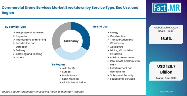
Commercial Drone Services Market Breakdown By Service Type, End Use, And Region | Source: Fact.MR
| Attribute | Details |
|---|---|
| Quantitative Units | USD billion in 2026 to USD billion by 2036 at a CAGR |
| Market Definition | Commercial drone services are outsourced or managed drone-based operations used for aerial imaging, mapping, inspection, delivery, spraying, seeding, detection, monitoring and related data delivery. |
| Service Type | Mapping and Surveying; Inspection; Photography and Filming; Localization and Detection; Delivery; Spraying and Seeding; Others |
| End Use | Energy; Construction; Transportation and Warehouse; Agriculture; Mining, Oil and Gas Extraction; Public Administration; Real Estate and Industrial Plant; Entertainment and Recreational; Safety and Security; Educational Services; Waste Management; Healthcare and Insurance |
| Product | Aerial Imaging Services; Surveying & Mapping Services; Inspection Services; Delivery & Logistics Drone Services |
| Application | Construction & Infrastructure; Agriculture Applications; Energy & Utilities Applications; Media & Entertainment |
| Regions Covered | North America; Latin America; Western Europe; Eastern Europe; East Asia; South Asia & Pacific; Middle East & Africa |
| Countries Covered | USA; South Korea; Germany; Japan; UK; France; Italy |
| Companies Profiled | AeroVironment, Inc.; Delair; Yamaha Motor Co., Ltd.; Terra Drone Corporation; Cyberhawk; Percepto; Matternet, Inc.; Wing Aviation LLC; Amazon.com, Inc. (Prime Air); Zipline; Flytrex; Skyports Drone Services; DroneDeploy; Rakuten Group, Inc. (Rakuten Drone) |
| Forecast Period | 2026 to 2036 |
| Approach | Hybrid top-down and bottom-up approach using service demand, application mix, regulatory readiness, country adoption, provider portfolios and verified public evidence. |
How is the market segmented?
-
By Service Type
- Mapping and Surveying
- Aerial Mapping
- Land Surveying
- Infrastructure Mapping
- Inspection
- Industrial Inspection
- Infrastructure Inspection
- Facility Inspection
- Photography and Filming
- Commercial Photography
- Cinematography
- Media Content Creation
- Localization and Detection
- Object Detection
- Surveillance Detection
- Environmental Detection
- Delivery
- Last Mile Delivery
- Medical Delivery
- Industrial Delivery
- Spraying and Seeding
- Crop Spraying
- Seed Distribution
- Field Monitoring
- Others
- Research Services
- Training Services
- Custom Drone Operations
- Mapping and Surveying
-
By End Use
- Energy
- Renewable Energy
- Utility Infrastructure
- Oil and Gas Facilities
- Construction
- Site Monitoring
- Infrastructure Development
- Building Development
- Transportation and Warehouse
- Logistics Operations
- Supply Chain Management
- Transportation Infrastructure
- Agriculture
- Precision Agriculture
- Farm Operations
- Livestock Monitoring
- Mining, Oil and Gas Extraction
- Mining Operations
- Oil Extraction
- Gas Extraction
- Public Administration
- Municipal Operations
- Disaster Management
- Public Infrastructure
- Real Estate and Industrial Plant
- Real Estate Services
- Industrial Facilities
- Commercial Property
- Entertainment and Recreational
- Film and Media
- Event Coverage
- Recreational Services
- Safety and Security
- Public Safety
- Private Security
- Defense Support
- Educational Services
- Academic Training
- Research Programs
- Simulation Services
- Waste Management
- Landfill Monitoring
- Recycling Operations
- Hazardous Waste Management
- Energy
-
By Product
- Aerial Imaging Services
- Photogrammetry Services
- Cinematic Drone Filming Services
- Surveying & Mapping Services
- Land Survey Services
- Geospatial Mapping Services
- Inspection Services
- Industrial Inspection Services
- Infrastructure Monitoring Services
- Delivery & Logistics Drone Services
- Last Mile Delivery Services
- Industrial Logistics Services
- Aerial Imaging Services
-
By Application
- Construction & Infrastructure
- Site Monitoring Applications
- Surveying Applications
- Agriculture Applications
- Precision Farming Applications
- Irrigation Management Applications
- Energy & Utilities Applications
- Power Infrastructure Monitoring
- Oil & Gas Monitoring
- Media & Entertainment
- Film Production Applications
- Advertising Applications
- Construction & Infrastructure
-
By Region
- North America
- Latin America
- Western Europe
- Eastern Europe
- East Asia
- South Asia & Pacific
- Middle East & Africa