- Market Value (2025): USD 2.3 Bn
- Estimated Value (2026): USD 2.6 Bn
- Forecast Value (2036): USD 7.7 Bn
- CAGR (2026-2036): 11.4%
What is the Drone Construction Monitoring Market forecast to be worth by 2036?
USD 2.6 billion in 2026 to USD 7.7 billion by 2036 at an 11.4% CAGR.
- The Drone Construction Monitoring Market reached USD 2.3 billion in 2025.
- Demand is projected to increase from USD 2.6 billion in 2026 to USD 7.7 billion by 2036.
- The market is forecast to record 11.4% CAGR from 2026 to 2036, supported by repeat site mapping and AI based progress checks.
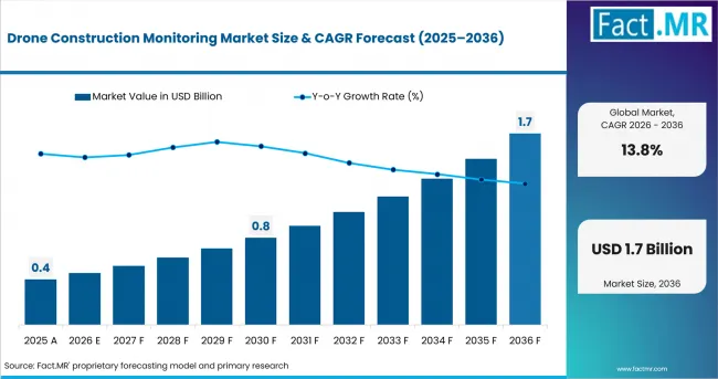
Drone Construction Monitoring Market Value Analysis | Source: Fact.MR
What are the defining numbers behind Drone Construction Monitoring Market growth?
An absolute opportunity of USD 5.1 billion is expected between 2026 and 2036.
- Demand Drivers in the Market
- Project teams need repeat aerial records when earthwork, structure work and envelope work move at different speeds. Drone monitoring gives them a common visual record for schedule review.
- Large jobsites need wider coverage than ground photos usually provide. Fixed wing drones are projected to serve this need through longer flight paths and wider survey coverage.
- Safety managers need visibility into roofs, edges and heavy-equipment zones without sending workers into every area. Drone records are anticipated to support safer inspection routines where site access is difficult.
- Key Segments Analyzed
- By Product: Fixed Wing Drones are expected to hold 56.80% share in 2026, supported by broad site coverage and repeat mapping needs on large parcels.
- By End Use: Residential Construction is projected to account for 36.90% share in 2026, reflecting frequent milestone checks across housing projects.
- By Application: Site Surveying and Mapping is anticipated to capture 33.40% share in 2026, attributable to topographic review and boundary verification work.
- By Technology: AI Based Drone Analytics is estimated to represent 68.40% share in 2026, owing to automated change detection and progress comparison.
- Analyst Opinion at Fact.MR
- Shambhu Nath Jha, Principal Consultant at Fact.MR, states, “Construction monitoring is becoming a documentation workflow rather than a camera task. The market is expected to reward platforms that connect flight planning, map outputs and schedule review. Suppliers should prove accuracy, field repeatability and simple handoff to project managers.”
- Strategic Implications
- Drone hardware vendors should pair longer flight endurance with simple mission planning so site teams repeat the same route safely every week.
- Analytics providers should focus on work-in-place comparison since managers need faster proof across floor plates, roofs and earthworks.
- Construction contractors should train field teams on capture discipline so drone outputs match schedules, drawings and payment reviews.
- Software partners should connect aerial data with BIM and project controls, supported by clean exports that site managers already use.
USA is projected to record 14.5% CAGR through 2036, supported by large construction spending and safety documentation needs. South Korea is expected to post 13.5% CAGR, owing to a wide contractor base and active building contracts. UK is anticipated to advance at 13.2% CAGR, reflecting output recovery and tighter cost visibility. Germany is forecast to hold 13.0% CAGR, driven by residential permit recovery and infrastructure oversight. France is estimated to reach 12.8% CAGR, supported by housing authorization activity and renovation monitoring. Italy is projected to register 12.2% CAGR, attributable to construction production recovery and survey use. Japan is expected to record 12.0% CAGR, led by regulated UAS workflows and safety-led site review.
How does the Drone Construction Monitoring Market break down by segment?
Fixed Wing Drones leads Product at 56.80%; AI Based Drone Analytics leads Technology at 68.40%.
Which Product dominates?
Fixed Wing Drones are expected to hold 56.80% share in 2026.
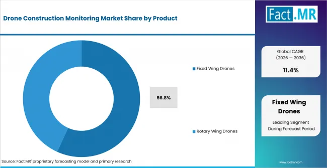
Drone Construction Monitoring Market Analysis By Product | Source: Fact.MR
Fixed Wing Drones are expected to lead Product with 56.80% share in 2026, supported by their fit with broad-area mapping. Large fixed wing drones suit roads, utilities and land development sites where coverage per flight reduces field time.
What leads the End Use segment?
Residential Construction is projected to account for 36.90% share in 2026.
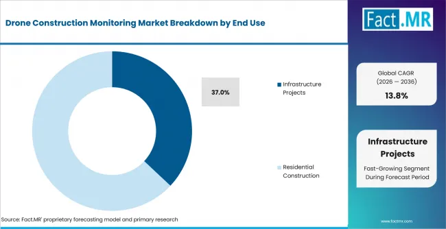
Drone Construction Monitoring Market Analysis By End Use | Source: Fact.MR
Residential Construction is projected to account for 36.90% share in 2026, reflecting frequent progress checks across housing sites. Commercial Construction needs similar evidence for office, retail and hospitality projects.
How does Application shape demand?
Site Surveying and Mapping is anticipated to capture 33.40% share in 2026.
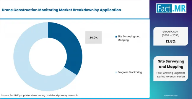
Drone Construction Monitoring Market Analysis By Application | Source: Fact.MR
Site Surveying and Mapping is anticipated to capture 33.40% share in 2026, attributable to topographic mapping and boundary review. Progress Monitoring follows as managers compare actual work with schedule milestones.
What supports Technology adoption?
AI Based Drone Analytics is estimated to represent 68.40% share in 2026.
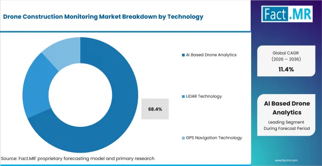
Drone Construction Monitoring Market Analysis By Technology | Source: Fact.MR
AI Based Drone Analytics is estimated to represent 68.40% share in 2026, owing to automated comparison between captured imagery and project plans. Pix4D added georeferenced Gaussian splatting for drone datasets in PIX4Dcloud in October 2025.
What is accelerating Drone Construction Monitoring Market adoption, and what is holding it back?
Site documentation drives it; flight compliance restrains it.
Drivers Impact Analysis
| DRIVER | (~) % IMPACT ON CAGR | GEOGRAPHIC RELEVANCE | IMPACT TIMELINE |
|---|---|---|---|
| Repeat site documentation for schedule review | +2.0% | North America, Europe, East Asia | Short term (<= 2 years) |
| Wide-area mapping for residential and infrastructure projects | +1.6% | USA, Germany, France, Japan | Medium term (2-4 years) |
| AI based progress comparison and work-in-place tracking | +1.4% | Global | Medium term (2-4 years) |
| Safety inspection of roofs, edges and restricted areas | +1.1% | USA, UK, Japan | Short term (<= 2 years) |
Source: Fact.MR analysis. Updated Sep 2, 2026
- Repeat site documentation: Construction teams are expected to adopt drone monitoring when visual records reduce disagreement about completed work. Repeat flights give managers a stable record for weekly progress review.
- Wide-area mapping: Fixed wing drones are projected to gain use on large parcels and linear assets. Residential builders and utility owners need fast coverage across changing ground conditions.
- AI based progress comparison: AI Based Drone Analytics is anticipated to raise the value of captured imagery. Automated change detection helps managers move from photo storage to task-level review.
- Safety inspection: Drone monitoring is expected to support safer checks around roofs, edges and restricted zones. Aerial review gives site teams another way to see high-risk areas before field checks.
Opportunity Impact Analysis
| OPPORTUNITY | (~) % IMPACT ON CAGR | GEOGRAPHIC RELEVANCE | IMPACT TIMELINE |
|---|---|---|---|
| AI progress tracking linked to project schedules | +1.5% | Global | Short term (<= 2 years) |
| Residential construction monitoring packages | +1.2% | USA, UK, France, Germany | Medium term (2-4 years) |
| LiDAR and 3D mapping for terrain-heavy sites | +1.0% | North America, Europe, East Asia | Long term (>= 4 years) |
Source: Fact.MR analysis. Updated Sep 2, 2026
- AI progress tracking: The primary opportunity is concentrated in automated work-in-place review. Software providers are expected to win accounts when aerial capture, ground capture and project controls connect in one flow.
- Residential monitoring packages: Residential Construction is projected to remain attractive since housing sites need repeated milestone records. Builders with many sites need consistent capture standards across project teams.
- LiDAR and 3D mapping: LiDAR Technology is anticipated to expand where terrain and structural detail shape project review. Drone laser scans support earthwork volumes and as-built comparisons.
Restraints Impact Analysis
| RESTRAINT | (~) % IMPACT ON CAGR | GEOGRAPHIC RELEVANCE | IMPACT TIMELINE |
|---|---|---|---|
| Flight permissions near urban or controlled airspace | -0.8% | USA, UK, Japan, Europe | Short term (<= 2 years) |
| Data-quality gaps from inconsistent capture routines | -0.6% | Global | Medium term (2-4 years) |
| Limited survey skills among smaller contractors | -0.5% | Global | Medium term (2-4 years) |
Source: Fact.MR analysis. Updated Sep 2, 2026
- Flight permissions: Commercial drone flights are expected to face extra planning near airports, dense cities and sensitive facilities. Delays affect monitoring value when flights need a weekly rhythm.
- Data-quality gaps: Drone monitoring is constrained when capture height, route and ground control vary between flights. Inconsistent datasets reduce the value of progress comparison.
- Limited survey skills: Smaller contractors often lack teams trained in survey-grade capture and map interpretation. Partner-led service models help these contractors use aerial data without building full internal teams.
Which countries are scaling the Drone Construction Monitoring Market through 2036?
- The country comparison spans 2.5 percentage points and forms a compact growth range across the forecast period.
- The USA remains 1.0 percentage point above South Korea through large project volumes and repeat documentation needs.
- South Korea remains 0.3 percentage point above the UK as contractor density supports drone service expansion.
- The UK remains 0.2 percentage point above Germany through output recovery and cost visibility requirements.
- Germany remains 0.2 percentage point above France as permit recovery improves the site pipeline for monitoring tools.
- France remains 0.6 percentage point above Italy through housing authorization activity and renovation oversight.
- Italy remains 0.2 percentage point above Japan while Japan closes the displayed range through regulated UAS workflows.
Comparable CAGRs create different entry conditions due to construction mix, aviation approvals, contractor digital maturity and safety expectations. Full report coverage includes North America, Latin America, Western Europe, Eastern Europe, East Asia, South Asia and Pacific, Middle East and Africa.
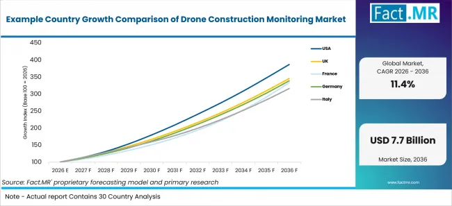
Example Country Growth Comparison Of Drone Construction Monitoring Market | Source: Fact.MR
| Country | CAGR (2026-2036) |
|---|---|
| USA | 14.5% |
| South Korea | 13.5% |
| UK | 13.2% |
| Germany | 13.0% |
| France | 12.8% |
| Italy | 12.2% |
| Japan | 12.0% |
Source: Fact.MR analysis. Updated Sep 2, 2026
What supports USA adoption?
14.5% CAGR, supported by construction spending and repeat site documentation.
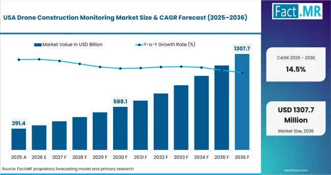
Drone Construction Monitoring Market Country Value Analysis | Source: Fact.MR
The U.S. Census Bureau estimated June 2026 construction spending at a seasonally adjusted annual rate of USD 2,166.5 billion in August 2026. This large construction base supports recurring drone use for site mapping, progress documentation, safety review, and project oversight across residential, commercial, industrial, and infrastructure projects.
How is South Korea scaling demand?
13.5% CAGR, driven by contractor density and digital site control.
South Korea’s Ministry of Data and Statistics reported in August 2026 that the country had 89,590 construction enterprises in 2025. This broad contractor base supports drone adoption for digital site control, progress monitoring, mapping, safety checks, and documentation across projects where frequent visual updates can improve coordination and oversight.
What supports the UK outlook?
13.2% CAGR, backed by output recovery and cost visibility needs.
The Office for National Statistics reported in February 2026 that annual construction output in Great Britain increased by 1.8% in 2025. Improving construction activity supports drone demand for progress tracking, survey documentation, cost visibility, and remote site review as contractors seek efficient ways to monitor changing project conditions.
What underpins Germany's growth?
13.0% CAGR, supported by housing permits and infrastructure oversight.
Germany’s Federal Statistical Office reported in February 2026 that dwelling building permits rose 10.8% in 2025. Expanding housing authorization activity supports drone use for site surveying, progress documentation, and infrastructure oversight, particularly where contractors need repeatable aerial records across larger developments and complex construction environments.
How is France developing demand?
12.8% CAGR, led by housing authorization activity and renovation monitoring.
SDES reported in July 2026 that 376,241 dwellings were authorized for construction in France from July 2025 to June 2026. This authorization activity supports drone demand for surveying, renovation monitoring, progress documentation, and site inspection as contractors and owners seek consistent visual records across residential and infrastructure projects.
What supports Italy's adoption?
12.2% CAGR, shaped by construction production recovery and survey use.
Istat reported in February 2026 that Italy’s calendar-adjusted construction production increased 5.4% year over year in December 2025. Improving construction activity supports drone adoption for surveying, progress monitoring, site documentation, and safety review, particularly where contractors need efficient visual records across multiple stages of project execution.
How does Japan perform?
12.0% CAGR, supported by safety-led site review and regulated UAS workflows.
Japan’s Ministry of Health, Labour and Welfare reported in May 2026 that construction recorded 214 work-related deaths in 2025. This safety context supports demand for drone-based site review, inspection, and monitoring that can reduce worker exposure while fitting regulated UAS workflows used across construction and infrastructure projects.
Who leads the Drone Construction Monitoring Market?
Teledyne FLIR LLC, DroneDeploy, Pix4D SA and Delair are profiled across sensing, mapping and construction-monitoring workflows.
Teledyne FLIR LLC supports drone operators through thermal imaging and aerial sensing, while DroneDeploy connects aerial and ground reality capture for construction progress review. Pix4D SA strengthens the software layer through photogrammetry, cloud mapping and 3D visualization. Delair adds fixed wing mapping experience for land survey and infrastructure work.
DJI Enterprise and Yuneec International Co. Ltd. are included in the report’s enterprise-drone hardware set for construction, surveying and inspection use cases. Skydio, Inc. is profiled for autonomous drone workflows used in site progress and remote operations. Competition is expected to be shaped by repeatable capture, map accuracy, AI progress tracking and easy handoff to project teams.
Which companies are profiled in the market?
Key companies include Teledyne FLIR LLC, DroneDeploy, Pix4D SA, Delair, DJI Enterprise, Yuneec International Co. Ltd. and Skydio, Inc.
- Teledyne FLIR LLC
- DroneDeploy
- Pix4D SA
- Delair
- DJI Enterprise
- Yuneec International Co. Ltd.
- Skydio, Inc.
Bibliography
- U.S. Census Bureau. (2026, August 3). Monthly construction spending, June 2026.
- Office for National Statistics. (2026, February 12). Construction output in Great Britain: December 2025, new orders and Construction Output Price Indices, October to December 2025.
- Statistisches Bundesamt (Destatis). (2026, February 18). 10,8 % mehr Baugenehmigungen für Wohnungen im Jahr 2025 [10.8% more building permits for dwellings in 2025].
- Service des données et études statistiques. (2026, July 28). Construction de logements : résultats à fin juin 2026 (France entière).
- Istituto Nazionale di Statistica. (2026, February 11). Production in the construction sector – December 2025.
- DroneDeploy News Team. (2025, July 22). DroneDeploy redefines progress tracking in construction with launch of Progress AI.
- Pix4D. (2025, October 7). PIX4Dcloud has georeferenced Gaussian splatting for drones.
This Report Answers
- The report explains where drone construction monitoring is used across product and end use. It also connects the analysis with adjacent construction drone services and drone surveying coverage.
- Segment analysis identifies the leading subsegments and the operational reasons contractors prioritize them. It covers drone GIS mapping and fixed wing drone workflows where site coverage shapes supplier choice.
- Country analysis examines USA, South Korea, UK, Germany, France, Italy and Japan. It considers construction activity, aviation workflows and the role of drone land surveying in repeat site records.
- Competitive analysis reviews Teledyne FLIR LLC, DroneDeploy, Pix4D SA, Delair, DJI Enterprise, Yuneec International Co. Ltd. and Skydio, Inc. It considers software depth, hardware fit and enterprise drone management needs.
- Application analysis covers surveying, progress monitoring, safety checks, equipment tracking and post construction audit. It also links construction use cases with UAV inspection drones and industrial drone monitoring coverage.
What does the Drone Construction Monitoring Market cover?
Fixed wing drones, rotary wing drones, mapping software and AI analytics used for construction site monitoring.
The Drone Construction Monitoring Market covers drone hardware, flight workflows and analytics used to record construction progress. It includes systems used for topographic mapping, site surveying, safety inspections, equipment tracking and post construction audit.
The market differs from broad drone services because the scope is limited to construction monitoring use cases. It includes drone laser scanning when LiDAR or 3D outputs support active site review, survey checks or project documentation.
What is included in the scope?
Drone construction monitoring systems used across active construction projects.
The scope includes fixed wing drones, rotary wing drones, AI Based Drone Analytics, LiDAR Technology, 3D mapping systems, geospatial analysis, GPS navigation and autonomous flight systems used on active construction sites. It covers residential, commercial, industrial and infrastructure projects where aerial records support site decisions.
What is excluded from the scope?
Consumer aerial photography and non-construction inspection are outside the scope.
The scope excludes recreational drone use, entertainment filming, agriculture mapping and defense applications. Real estate photography is excluded when images are used only for marketing. Generic building inspection after handover is outside scope unless it forms part of a construction closeout audit.
How Was the Analysis Built?
The analysis draws on 120+ sources, 35+ company portfolios, 25+ countries, and more than 20 industry interviews.
- Primary Research: Primary research includes discussions with manufacturers, service providers, technology developers, distributors, end users, and subject-matter experts. These conversations examine purchasing priorities, product adoption, operational challenges, approval requirements, competitive positioning, and the factors that influence wider market acceptance.
- Desk Research: Desk research covers government statistics, regulatory publications, company filings, trade data, technical studies, industry associations, standards, public policy, and other authoritative sources. Every source used in the analysis is documented in the bibliography.
- Market Sizing and Forecasting: Market estimates combine historical performance, demand indicators, pricing and volume trends, segment shares, company participation, country-level growth, adoption patterns, investment activity, and barriers to market expansion.
- Data Validation and Update Cycle: Findings are validated by comparing primary interviews with public data, company activity, regulatory changes, trade patterns, and industry developments. Regular updates review new product launches, capacity changes, partnerships, approvals, and shifts in commercial adoption.
Segmentation
What is the report’s scope and coverage?
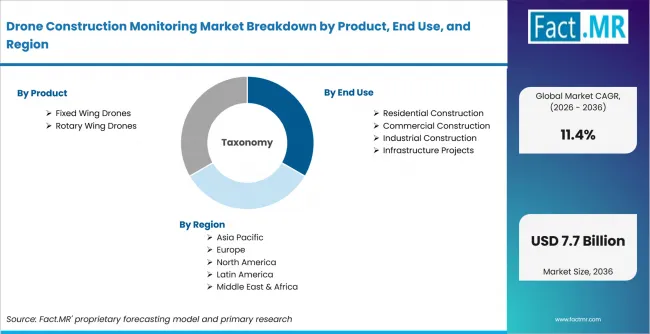
Drone Construction Monitoring Market Breakdown By Product, End Use, And Region | Source: Fact.MR
| Attribute | Details |
|---|---|
| Quantitative Units | USD billion |
| Market Definition | Drone systems and software used to monitor construction sites through aerial capture, mapping, inspection and analytics. |
| Product | Fixed Wing Drones, Rotary Wing Drones |
| End Use | Residential Construction, Commercial Construction, Industrial Construction, Infrastructure Projects |
| Application | Site Surveying and Mapping, Progress Monitoring, Safety Inspections, Equipment Tracking, Post Construction Audit, Others |
| Technology | AI Based Drone Analytics, LiDAR Technology, GPS Navigation Technology |
| Regions Covered | North America; Latin America; Western Europe; Eastern Europe; East Asia; South Asia and Pacific; Middle East and Africa |
| Countries Covered | USA; South Korea; UK; Germany; France; Italy; Japan |
| Key Companies Profiled | Teledyne FLIR LLC; DroneDeploy; Pix4D SA; Delair; DJI Enterprise; Yuneec International Co. Ltd.; Skydio, Inc. |
| Forecast Period | 2026 to 2036 |
| Approach | Hybrid top-down and bottom-up approach using construction activity, drone applications, portfolio review, country indicators and interviews. |
Source: Fact.MR analysis. Updated Sep 2, 2026
How is the market segmented?
-
By Product
- Fixed Wing Drones
- Small Fixed Wing Drones
- Large Fixed Wing Drones
- Rotary Wing Drones
- Single Rotor Drones
- Multi Rotor Drones
- Fixed Wing Drones
-
By End Use
- Residential Construction
- Single Family Housing Projects
- Multi Family Housing Projects
- Commercial Construction
- Office and Business Complexes
- Retail and Hospitality Projects
- Industrial Construction
- Manufacturing Facilities
- Energy and Utility Facilities
- Infrastructure Projects
- Transportation Infrastructure
- Public Utility Infrastructure
- Residential Construction
-
By Application
- Site Surveying and Mapping
- Topographic Mapping
- Land and Boundary Surveying
- Progress Monitoring
- Real Time Project Tracking
- Workflow Optimization
- Safety Inspections
- Worker Safety Monitoring
- Structural Safety Inspection
- Equipment Tracking
- Heavy Equipment Monitoring
- Material and Asset Tracking
- Post Construction Audit
- Quality Assessment
- Project Documentation
- Others
- Environmental Monitoring
- Security and Surveillance
- Site Surveying and Mapping
-
By Technology
- AI Based Drone Analytics
- Computer Vision Systems
- Predictive Analytics Systems
- LiDAR Technology
- 3D Mapping Systems
- Geospatial Analysis Systems
- GPS Navigation Technology
- RTK GPS Systems
- Autonomous Flight Systems
- AI Based Drone Analytics
-
By Region
- North America
- Latin America
- Western Europe
- Eastern Europe
- East Asia
- South Asia and Pacific
- Middle East and Africa
Frequently Asked Questions
How big is the Drone Construction Monitoring Market in 2026?
What is the CAGR of the Drone Construction Monitoring Market from 2026 to 2036?
Which product leads the Drone Construction Monitoring Market?
Which technology leads the Drone Construction Monitoring Market?
Which companies are profiled in the Drone Construction Monitoring Market?
Who worked on this report


Preview the report firsthand - request a free sample
Free SampleGet the brochure for pricing and purchase details
Download PDF