- Market Value (2025): USD 6.3 Bn
- Estimated Value (2026): USD 7.2 Bn
- Forecast Value (2036): USD 27.6 Bn
- CAGR (2026-2036): 14.4%
What is the Surveillance Drone Market forecast to be worth by 2036?
USD 27.6 billion by 2036 at a 14.4% CAGR.
- The surveillance drone market reached USD 6.3 billion in 2025.
- Demand is projected to rise from USD 7.2 billion in 2026 to USD 27.6 billion by 2036.
- The market is projected to expand at a 14.4% CAGR from 2026 to 2036.
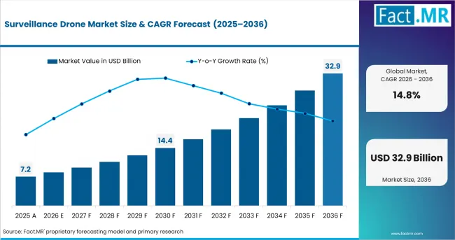
Surveillance Drone Market Value Analysis | Source: Fact.MR
What are the defining numbers behind Surveillance Drone Market growth?
An absolute opportunity of USD 20.4 billion is expected between 2026 and 2036.
- Demand Drivers in the Market
- Security agencies are moving from occasional aerial observation toward persistent, sensor-led coverage. The U.S. Border Patrol 2025-2029 Strategy explicitly calls for advanced autonomous surveillance systems, including drones, unmanned systems and AI-driven analytics, to extend detection coverage in high-priority border zones. That model increases demand for aircraft, electro-optical and thermal payloads, command links and mission software that can remain available for repeated patrol cycles.
- Regulatory work on longer-range operations is widening the addressable mission set. The FAA proposed a dedicated BVLOS framework in August 2025, while EASA incorporated SORA 2.5 into its June 2026 unmanned-aircraft rules. These changes matter for corridor, perimeter and infrastructure missions that cannot be served efficiently by short local flights alone, and they strengthen the operating case for drone services built around recurring monitoring.
- Maritime surveillance is becoming a repeat procurement use case rather than a demonstration activity. The U.S. Coast Guard reported in its April 2025 UAS capability fact sheet that shipborne UAS provide persistent airborne intelligence, surveillance and reconnaissance, with more than 8,000 flight hours logged across seven years of operations. Long endurance, ship-compatible launch and recovery, and multi-sensor payloads therefore translate directly into replacement and fleet-expansion demand.
- Autonomous mission planning, remote docking and AI-assisted video analysis are reducing the amount of operator time required for routine perimeter rounds. These capabilities are especially relevant to industrial sites and critical infrastructure, where a smart drone can repeat the same route, compare imagery over time and escalate only abnormal events to a human operator.
- Public-safety and emergency users value drones because they can place thermal or optical sensors over dangerous areas without committing a crewed aircraft or exposing responders at the same distance. Fire, search-and-rescue and disaster-response agencies increasingly use unmanned systems for wide-area situational awareness, hot-spot detection and route assessment, creating demand outside traditional defense and border-security procurement.
- Key Segments Analyzed
- Fixed Wing Drone accounts for 35.9% of Type in 2026 because endurance, efficient forward flight and payload capacity suit long border corridors, coastlines and wide-area patrol routes where coverage per sortie is a primary buying criterion.
- Visual Line of Sight (VLOS) represents 38.7% of Range in 2026 because local perimeter, public-safety and commercial surveillance missions can be launched quickly under comparatively straightforward operating conditions while keeping direct pilot awareness of the aircraft.
- Remotely Piloted accounts for 42.1% of Mode of Operation in 2026 because security missions often require human judgement during target confirmation, route changes, evidence capture and coordination with ground teams even when navigation and stabilization are highly automated.
- Border Surveillance holds 22.3% of Application in 2026 because long, remote and difficult-to-access boundaries create recurring demand for airborne detection, tracking and situational awareness that complements towers, ground patrols, radar and fixed cameras.
- Analyst Opinion at Fact.MR
- Shambhu Nath Jha, Principal Consultant, Fact.MR, states, “Surveillance drone procurement is increasingly shaped by mission persistence rather than airframe novelty. Buyers want enough endurance for the patrol area, sensors that work in day and night conditions, secure links, reliable geolocation and a workflow that can move an alert from the aircraft to a ground team without delay. The stronger suppliers will be those that can integrate aircraft, payload, autonomy and command software around the operating rules of the customer, because surveillance value is created by usable coverage and response time rather than flight capability in isolation.”
- Strategic Implications
- Fixed-wing suppliers should prioritize endurance, resilient command links and payload modularity for border and maritime users, while multi-rotor suppliers should emphasize rapid launch, hover stability and confined-site operation. This creates distinct product economics within the broader drone market rather than a single airframe architecture winning every surveillance mission.
- Manufacturers serving BVLOS or BLOS missions need to design compliance into the platform. Detect-and-avoid capability, remote identification, flight logging, command-and-control resilience and documented failure procedures increasingly influence whether an operator can secure approval for repeated long-range missions.
- Thermal, low-light, zoom and radar payloads should be treated as mission systems rather than optional accessories. Border, industrial, forest and maritime buyers evaluate whether the sensor can identify the event that matters at the required stand-off distance, not simply whether the aircraft can reach the location.
- Operators with recurring inspection and perimeter contracts can use service models to reduce customer capital requirements. The economics resemble professional drone services where the customer buys an operational outcome that combines aircraft availability, trained personnel, maintenance, approvals and data delivery.
- Cybersecurity and data governance will increasingly separate qualified security platforms from general-purpose drones. Government and industrial buyers need secure control links, access management, traceable mission records and defined storage policies because surveillance data may include sensitive infrastructure, border movements or emergency operations.
How does the Surveillance Drone Market break down by segment?
The market is segmented by Type, Range, Mode of Operation and Application.
Why does Fixed Wing Drone lead Type?
Fixed Wing Drone is projected to account for a 35.9% share in 2026.
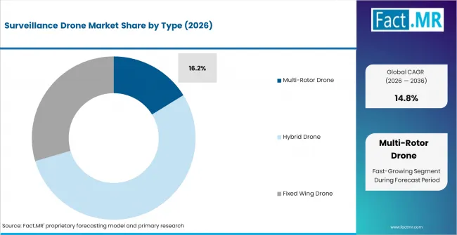
Surveillance Drone Market Analysis By Type | Source: Fact.MR
Fixed-wing aircraft convert propulsion energy into forward coverage efficiently, which makes them well suited to long linear missions such as border sectors, coastlines, pipelines and large restricted areas. Operators can spend more of a sortie observing the mission area rather than repeatedly repositioning a short-endurance platform.
The operational logic is visible in public procurement. The French Gendarmerie began introducing the fixed-wing DT46 in 2025 for extended surveillance and reconnaissance, citing up to six hours of endurance and a 100-kilometer operating radius. Germany also uses long-endurance unmanned aircraft for reconnaissance, including the German Heron TP, which the Bundeswehr describes as capable of lengthy sensor-based observation missions.
Multi-rotor drones remain important where hover, vertical takeoff and close-quarter maneuvering dominate. Hybrid designs reduce the trade-off by combining vertical launch with more efficient cruise, but fixed-wing platforms retain a clear role when buyers value patrol radius and time on station across wide areas.
Why does Visual Line of Sight (VLOS) lead Range?
Visual Line of Sight (VLOS) is projected to account for a 38.7% share in 2026.
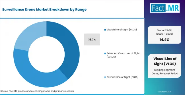
Surveillance Drone Market Analysis By Range | Source: Fact.MR
VLOS missions cover many practical surveillance jobs without the additional risk case required for longer-range unmanned flight. Security teams can launch from a facility, incident scene, forest edge or local patrol point, keep the aircraft directly observable and use optical or thermal sensors to extend what personnel can see from the ground.
Current regulation reinforces that operating advantage. FAA Part 107 continues to use visual-line-of-sight requirements for routine small UAS operations, while the UK CAA distinguishes BVLOS activity as a higher-complexity operation requiring specific authorization. In the EU system, operations outside the open-category limitations move into the specific category and can require SORA, a predefined risk assessment or an approved standard scenario.
EVLOS and BLOS missions expand coverage and reduce the need to reposition crews, so their commercial importance rises as detect-and-avoid, command-link assurance and airspace integration improve. VLOS nevertheless remains practical for frequent local surveillance where speed of deployment and regulatory simplicity matter more than maximum range.
Why does Remotely Piloted lead Mode of Operation?
Remotely Piloted is projected to account for a 42.1% share in 2026.
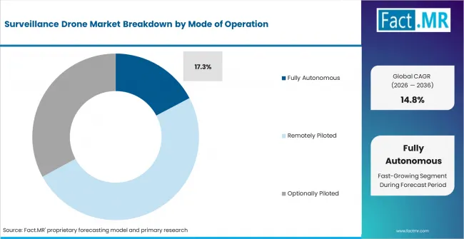
Surveillance Drone Market Analysis By Mode Of Operation | Source: Fact.MR
Surveillance frequently involves uncertainty. A human operator may need to change altitude, alter the camera angle, follow a moving target, verify a thermal signature or coordinate with responders. Remote piloting preserves direct human authority over these decisions while flight-control software handles stabilization, route assistance and return-to-home functions.
That operating model also aligns with regulatory structures built around accountable remote pilots. Japan requires remote-pilot certification for Level 4 operations, and the UK CAA framework places defined responsibilities on UAS operators and remote pilots. These requirements encourage automation that supports the operator rather than removing human accountability from the mission.
Optionally piloted and fully autonomous systems gain value where the same route must be repeated many times or where long missions create operator workload. Autonomous docking, pre-programmed routes and AI-enabled event detection can reduce routine intervention, but security customers still require escalation logic and human control for sensitive decisions.
Why does Border Surveillance lead Application?
Border Surveillance is projected to account for a 22.3% share in 2026.
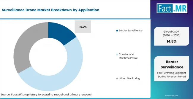
Surveillance Drone Market Analysis By Application | Source: Fact.MR
Borders combine distance, uneven terrain, sparse infrastructure and the need to detect activity outside fixed sensor locations. Drones can move cameras, radar and thermal sensors to changing points of interest, then provide coordinates and live imagery to officers or patrol teams. This gives agencies a flexible layer between fixed towers and crewed aircraft.
The U.S. Border Patrol 2025-2029 Strategy calls for advanced autonomous surveillance systems and aerial platforms to extend persistent detection coverage. CBP also states that its MQ-9 UAS supports land and maritime domain awareness with electro-optical, infrared and radar sensors used to detect, classify and track potential illicit activity.
Other applications are scaling for different reasons. Maritime patrol benefits from endurance and radar coverage, industrial perimeter surveillance benefits from repeatable routes and thermal inspection, and forest or disaster missions benefit from rapid access to hazardous areas. Border use nevertheless creates a sustained procurement case because the surveillance requirement is continuous rather than event-driven.
What is accelerating Surveillance Drone Market adoption, and what is holding it back?
Adoption is accelerating where airspace rules, payload performance and operational automation make surveillance missions repeatable rather than exceptional. EASA's SORA 2.5 framework gives operators a structured way to demonstrate risk controls for specific-category operations, while the UK CAA has published a pathway toward routine scalable BVLOS operations. Korea is using drone demonstration cities and special free zones to move operational concepts into real-world public-service environments.
Commercial deployment also benefits from service contracting. A security buyer can procure a monitored outcome instead of owning every aircraft, pilot and maintenance process, which is consistent with the emerging drone service model for recurring inspection and monitoring missions.
The main constraints are operational approval, airspace conflict risk, weather, link reliability, endurance-payload trade-offs and data-governance requirements. Surveillance platforms may need to fly near people, sensitive sites, controlled airspace or long distances, so an aircraft that performs well technically can still be unsuitable if the operator cannot demonstrate a compliant safety case or secure communications.
Privacy and proportionality rules also shape public-safety demand. France permits police and gendarmerie use of airborne cameras for defined public-security purposes but places limits on authorization duration, image use, sound capture and facial recognition. These controls do not eliminate demand, but they raise requirements for mission logging, access controls and disciplined data handling.
Drivers Impact Analysis
| Factor | (~) % Impact on CAGR | Geographic Relevance | Impact Timeline |
|---|---|---|---|
| Persistent border, maritime and critical-infrastructure surveillance procurement | +3.6% | USA, Europe, East Asia | 2026-2036 |
| Expansion of approved BVLOS and risk-based specific-category operations | +2.9% | USA, UK, France, Germany, Italy, Japan | 2027-2036 |
| Thermal, low-light, radar and AI-enabled sensor integration | +2.4% | Global | 2026-2034 |
| Public-safety, disaster and environmental monitoring programs | +1.8% | France, Italy, South Korea, Japan, USA | 2026-2033 |
Source: Fact.MR analysis. Updated Aug 26, 2026
Opportunity Impact Analysis
| Factor | (~) % Impact on CAGR | Geographic Relevance | Impact Timeline |
|---|---|---|---|
| Autonomous docked site surveillance | +2.7% | USA, UK, Germany, South Korea, Japan | 2027-2036 |
| Hybrid and long-endurance wide-area patrol | +2.2% | USA, France, Germany, Japan | 2026-2035 |
| Managed surveillance service contracts | +1.9% | USA, UK, France, Germany, Italy | 2026-2034 |
| Sensor fusion and automated event triage | +1.7% | Global | 2027-2036 |
Source: Fact.MR analysis. Updated Aug 26, 2026
Restraints Impact Analysis
| Factor | (~) % Impact on CAGR | Geographic Relevance | Impact Timeline |
|---|---|---|---|
| Airspace authorization and detect-and-avoid requirements for long-range missions | -2.0% | USA, UK, Europe, Japan | 2026-2031 |
| Privacy, data-retention and public-acceptance constraints on surveillance use | -1.5% | Europe, USA, Japan | 2026-2036 |
| Weather, endurance and payload trade-offs in persistent operations | -1.2% | Global | 2026-2036 |
| Secure communications, cyber hardening and integration costs | -1.0% | Government and critical-infrastructure markets | 2026-2034 |
Source: Fact.MR analysis. Updated Aug 26, 2026
Which countries are scaling the Surveillance Drone Market through 2036?
- USA: Border-security modernization and maritime ISR are creating demand for both small rapidly deployed drones and long-endurance platforms. CBP's 2025-2029 strategy calls for autonomous surveillance systems, while the U.S. Coast Guard is maintaining contracted shipborne UAS capability for persistent maritime awareness.
- UK: The CAA's BVLOS roadmap targets a progression toward routine scalable operations, opening a path for longer inspection, offshore-surveillance and public-service missions while Remote ID and product-standard changes strengthen the compliance framework.
- France: Police, gendarmerie and civil-security use is supported by a defined legal framework for airborne image capture. The Gendarmerie's 2025 DT46 program adds a medium-endurance fixed-wing capability for extended-area surveillance and reconnaissance.
- Germany: Public-safety authorities have a formal framework for UAS use in controlled zones, and defense procurement continues to add reconnaissance capability. The Bundeswehr's 2026 order for MQ-9B aircraft for maritime reconnaissance illustrates demand for long-endurance sensor platforms.
- Italy: ENAC's specific-category process supports authorized BVLOS and higher-risk professional operations, while fire and civil-protection organizations use remotely piloted aircraft for thermal monitoring, search and emergency situational awareness.
- South Korea: MOLIT is widening real-world drone deployment through demonstration cities and special free zones. The 2025 programs support local-government services and commercial testing, creating operating experience that can transfer to public-safety, infrastructure and environmental surveillance.
- Japan: MLIT's Level 4 framework permits certified unmanned aircraft to conduct approved BVLOS flights over inhabited areas. The framework explicitly identifies facility security, maritime search, disaster assessment, bridge inspection and forest-resource surveys among the use cases enabled by advanced operations.
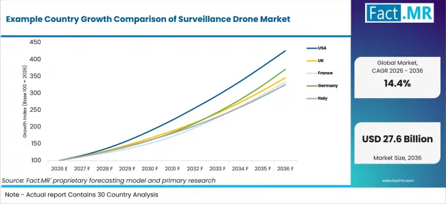
Example Country Growth Comparison Of Surveillance Drone Market | Source: Fact.MR
| Country | CAGR (2026-2036) |
|---|---|
| USA | 15.6% |
| UK | 13.2% |
| France | 12.8% |
| Germany | 14.0% |
| Italy | 12.5% |
| South Korea | 14.8% |
| Japan | 13.6% |
Source: Fact.MR analysis. Updated Aug 26, 2026
What is driving USA's growth through 2036?
The USA is forecast to expand at a 15.6% CAGR from 2026 to 2036.
Federal security missions create a direct equipment and service requirement. The U.S. Border Patrol 2025-2029 Strategy calls for expanded coverage from advanced autonomous surveillance systems, sensors, radar, drones and AI-driven analytics. CBP's MQ-9 program adds long-endurance electro-optical, infrared and radar coverage for land and maritime domain awareness, while smaller systems give field teams a rapidly deployable layer for local tracking.
Maritime use broadens the demand base. The U.S. Coast Guard reported in April 2025 that its national security cutter fleet had deployed UAS more than 1,200 times and logged more than 8,000 ISR flight hours over seven years. At the same time, the FAA's August 2025 BVLOS proposal is intended to establish a more scalable framework for operations beyond direct visual sight, which can reduce approval friction for recurring surveillance routes if finalized and implemented.
What is driving UK's growth through 2036?
The UK is forecast to expand at a 13.2% CAGR from 2026 to 2036.
The regulatory direction is moving toward repeatable BVLOS use. The UK CAA's October 2025 Future of Flight BVLOS Roadmap sets out operational pathways through 2027 and beyond, while its BVLOS guidance identifies uses such as offshore surveillance where operating outside direct visual sight can improve coverage and productivity.
Product and operating rules are also becoming more explicit. The CAA confirmed changes covering product requirements and Remote ID, with key UAS regulatory amendments taking effect from January 2026. That favors surveillance suppliers able to document aircraft identity, operating limitations, detect-and-avoid strategy and safe integration into the airspace rather than relying on ad hoc exemptions.
What is driving France's growth through 2036?
France is forecast to expand at a 12.8% CAGR from 2026 to 2036.
Public-security deployment has a defined legal basis. France's Ministry of the Interior states that police and gendarmerie can use cameras installed on drones for specified public-security purposes that include border surveillance, public-order support, transport-flow regulation and rescue, subject to authorization and data-use safeguards. This creates a recurring institutional use case while setting clear requirements for how imagery is handled.
Capability is also moving toward longer missions. In May 2025, the Gendarmerie described its DT46 fixed-wing drone as a medium-endurance system intended for extended-area surveillance and reconnaissance, with up to six hours of endurance and a 100-kilometer radius. DGAC's 2026 specific-category guidance provides structured pathways for professional BVLOS operations, including predefined risk assessments that can support surveillance over low-population areas and industrial sites.
What is driving Germany's growth through 2036?
Germany is forecast to expand at a 14.0% CAGR from 2026 to 2036.
Germany is formalizing how public-safety authorities use unmanned aircraft in controlled airspace. A 2025 Federal Ministry of Transport notice states that UAS are important for maintaining public safety and can support police, customs, search-and-rescue, border-control and coast-guard missions under the applicable legal framework. That clarity supports institutional procurement for missions where rapid aerial awareness is operationally valuable.
Defense surveillance adds a second demand channel. In January 2026, the Bundeswehr announced an order for eight MQ-9B drones for maritime reconnaissance and anti-submarine support, with sensor payloads including cameras and radar. Germany also operates smaller reconnaissance systems, so demand spans portable tactical surveillance through long-endurance maritime coverage rather than concentrating on one aircraft class.
What is driving Italy's growth through 2036?
Italy is forecast to expand at a 12.5% CAGR from 2026 to 2036.
ENAC's specific-category framework gives professional operators a defined route for missions that fall outside open-category limits, including BVLOS activity. Operators can use European standard scenarios, seek an operational authorization supported by SORA or PDRA, or operate under an LUC where the required organizational capability is demonstrated. That structure is important for industrial perimeter, infrastructure and public-safety surveillance that cannot always remain within simple VLOS conditions.
Emergency services provide visible operating demand. Italy's National Fire and Rescue Service uses remotely piloted aircraft to provide real-time high-resolution data during fires, floods, earthquakes and searches. In 2025, regional fire-service units reported using drones with thermal cameras to monitor large fires and identify hot zones, reinforcing the value of multi-rotor surveillance systems that can be deployed directly from an incident command area.
What is driving South Korea's growth through 2036?
South Korea is forecast to expand at a 14.8% CAGR from 2026 to 2036.
Government-backed demonstrations are lowering the gap between prototype and operational deployment. MOLIT selected 26 local governments for the 2025 Drone Demonstration City Project and seven companies for commercialization support, with public-service use cases built around local needs. This creates repeat flight experience, procurement references and safety procedures that can be adapted to monitoring and surveillance missions.
MOLIT expanded the policy environment again in July 2025 by designating 18 additional Drone Special Free Zones, bringing the total to 67 zones in 32 local governments. The zones simplify or exempt selected requirements for testing under local safety management, shortening the path to real-world demonstrations. For surveillance suppliers, this supports validation of autonomous patrol, public-safety, infrastructure and environmental monitoring systems before wider rollout.
What is driving Japan's growth through 2036?
Japan is forecast to expand at a 13.6% CAGR from 2026 to 2036.
Japan's Level 4 framework expands where unmanned aircraft can legally operate. MLIT states that certified aircraft flown by qualified remote pilots can conduct approved flights beyond visual line of sight over inhabited areas without ground access controls. The ministry lists disaster assessment, facility security, maritime search, bridge and plant inspection, surveying and forest-resource monitoring among the practical use cases enabled by the framework.
The operating system remains highly procedural, which favors professional platforms with strong compliance features. MLIT requires registration, flight permission or approval where applicable, flight-plan reporting and flight logbooks. Surveillance suppliers that can integrate geofencing, mission records, aircraft certification support and reliable command links are better positioned for municipal, infrastructure and security users seeking repeat operations rather than one-off demonstrations.
Who Leads the Surveillance Drone Market?
Key players in the Surveillance Drone Market include Aerodyne Group, Airobotics Ltd., BAE Systems Inc., Elbit Systems, Lockheed Martin Corporation, Thales Group, FLIR Systems, Teledyne FLIR, Raytheon Technologies, Leonardo S.p.A., SAAB AB, Percepto, Avitas Systems Inc., Sky-Futures Ltd., Sphere Drone, Tera Drone Corp., Viper Drones, Aesthetix Global, Cyberhawk Innovations Ltd., Martek Aviation, Mistras Group and Azure Drone SAS.
Aerodyne Group, Airobotics Ltd. and Percepto compete through drone-based inspection and surveillance platforms that combine autonomous flight operations with remote monitoring capabilities. Their positioning centers on enabling enterprises and infrastructure operators to conduct recurring aerial surveillance while integrating captured information into operational workflows.
BAE Systems Inc., Elbit Systems, Lockheed Martin Corporation, Thales Group, Raytheon Technologies, Leonardo S.p.A. and SAAB AB represent the defense-oriented competitive group. These companies participate through unmanned aerial systems, surveillance payloads, mission electronics, sensing technologies and command-and-control capabilities designed for security, defense and intelligence applications.
Teledyne FLIR strengthens the sensing side of the market through thermal imaging, electro-optical systems and drone-compatible surveillance technologies. FLIR Systems and Teledyne FLIR are best treated within the same competitive grouping rather than as separate strategic providers. Their relevance is tied to combining aerial platforms with imaging and detection technologies required for surveillance in complex operating environments.
Cyberhawk Innovations Ltd., Sky-Futures Ltd., Martek Aviation, Mistras Group and Avitas Systems Inc. are positioned around industrial inspection and asset-monitoring applications, while Tera Drone Corp., Sphere Drone and Viper Drones extend competition across commercial aerial surveillance and inspection services. Azure Drone SAS and Aesthetix Global add further specialist participation. Competition therefore centers on autonomous operation, sensing capability, platform reliability and the ability to integrate drone-collected information into security, infrastructure and industrial monitoring workflows.
Which companies are the key providers?
Aerodyne Group, Airobotics Ltd., BAE Systems Inc., Elbit Systems, Lockheed Martin Corporation, Thales Group, FLIR Systems, Teledyne FLIR, Raytheon Technologies, Leonardo S.p.A., SAAB AB, Percepto, Avitas Systems Inc., Sky-Futures Ltd., Sphere Drone, Tera Drone Corp., Viper Drones, Aesthetix Global, Cyberhawk Innovations Ltd., Martek Aviation, Mistras Group and Azure Drone SAS.
- Aerodyne Group
- Airobotics Ltd.
- BAE Systems Inc.
- Elbit Systems
- Lockheed Martin Corporation
- Thales Group
- FLIR Systems
- Teledyne FLIR
- Raytheon Technologies
- Leonardo S.p.A.
- SAAB AB
- Percepto
- Avitas Systems Inc.
- Sky-Futures Ltd.
- Sphere Drone
- Tera Drone Corp.
- Viper Drones
- Aesthetix Global
- Cyberhawk Innovations Ltd.
- Martek Aviation
- Mistras Group
- Azure Drone SAS
Bibliography
- International Civil Aviation Organization. (2026). Annex 6 - Operation of Aircraft, Part IV - Remotely Piloted Aircraft Systems, Second Edition. ICAO.
- European Union Aviation Safety Agency. (2026). Easy Access Rules for Unmanned Aircraft Systems, Revision from June 2026. EASA.
- European Commission. (2026). Action Plan on Drone and Counter Drone Security. European Commission.
- Federal Aviation Administration. (2026). Small Unmanned Aircraft Systems Regulations, Part 107. U.S. Department of Transportation.
- Federal Aviation Administration. (2025). Proposed Rule for Beyond Visual Line of Sight Drone Operations. U.S. Department of Transportation.
- U.S. Customs and Border Protection. (2025). U.S. Border Patrol 2025-2029 Strategy. U.S. Department of Homeland Security.
- U.S. Customs and Border Protection. (2025). General Atomics MQ-9 Unmanned Aircraft System. U.S. Department of Homeland Security.
- United States Coast Guard. (2025). Unmanned Aircraft System Capability Fact Sheet. U.S. Department of Homeland Security.
- UK Civil Aviation Authority. (2025). Future of Flight BVLOS Roadmap, CAP3182. UK Civil Aviation Authority.
- UK Civil Aviation Authority. (2025). Review of UAS Regulations and Updated Rules for Safe Drone Growth. UK Civil Aviation Authority.
- Ministère de l’Intérieur. (2023). Nouvelle réglementation sur la captation d’images de drones dans un cadre administratif. Government of France.
- Gendarmerie nationale. (2025). Le drone à voilure fixe DT46 entre en scène. Government of France.
- Direction générale de l’aviation civile. (2026). Exploitation de drones en catégorie spécifique. Government of France.
- Bundesministerium für Verkehr. (2025). Einsatz von unbemannten Luftfahrzeugsystemen durch Behörden und Organisationen mit Sicherheitsaufgaben in Kontrollzonen. Federal Republic of Germany.
- Bundeswehr. (2026). Bundeswehr bestellt Drohnen zur Seefernaufklärung und U-Boot-Jagd. Federal Republic of Germany.
- Ente Nazionale per l’Aviazione Civile. (2026). Categoria specifica and Operational Authorization for UAS. Government of Italy.
- Corpo Nazionale dei Vigili del Fuoco. (2025). S.A.P.R. - Sistemi Aeromobili a Pilotaggio Remoto. Government of Italy.
- Ministry of Land, Infrastructure and Transport, Republic of Korea. (2025). K-Drone to Save Lives and More. Government of the Republic of Korea.
- Ministry of Land, Infrastructure and Transport, Republic of Korea. (2025). Lowering Regulatory Barriers by Drone Special Free Zones Nationwide. Government of the Republic of Korea.
- Ministry of Land, Infrastructure, Transport and Tourism, Japan. (2026). Unmanned Aircraft Level 4 Flight Web Portal. Government of Japan.
- Ministry of Land, Infrastructure, Transport and Tourism, Japan. (2025). Unmanned Aircraft Flight Permission and Approval Application Framework. Government of Japan.
- Teledyne Technologies Incorporated. (2021). Teledyne Completes Acquisition of FLIR. Teledyne Technologies Incorporated.
This Report Answers
- How do border, maritime and industrial surveillance requirements translate into drone platform demand?
- Why do fixed-wing drones retain a strong role alongside multi-rotor and hybrid designs?
- How are VLOS, EVLOS and BLOS operating models affected by airspace rules and risk-assessment requirements?
- Why does human remote piloting remain important as autonomous navigation and AI event detection expand?
- Which public-safety, security and regulatory mechanisms are shaping demand across the USA, UK, France, Germany, Italy, South Korea and Japan?
What does the Surveillance Drone Market cover?
The Surveillance Drone Market covers unmanned aerial platforms supplied for observation, monitoring, detection, reconnaissance and situational-awareness missions across the applications in the source taxonomy. Revenue is counted at the surveillance drone platform level, including integrated flight-control and mission systems supplied with the aircraft where they form part of the delivered drone system.
The assessment covers Type, Range, Mode of Operation and Application across the specified segment hierarchy, with detailed growth analysis for the USA, UK, France, Germany, Italy, South Korea and Japan.
What is included in the scope?
The scope includes Fixed Wing Drone, Multi Rotor Drone and Hybrid Drone platforms, including the specified long-endurance, tactical, commercial, quadcopter, hexacopter, octocopter, fixed-wing hybrid, VTOL hybrid and multi-mission variants.
Range includes Visual Line of Sight, Extended Visual Line of Sight and Beyond Line of Sight operations. Mode of Operation includes Remotely Piloted, Optionally Piloted and Fully Autonomous systems. Applications include Border Surveillance, Coastal and Maritime Patrol, Urban Monitoring, Industrial Perimeter Surveillance, Wildlife and Forest Surveillance, and the listed disaster, agricultural and event-surveillance uses within Others.
What is excluded from the scope?
The scope excludes recreational drones, consumer photography drones purchased without a surveillance mission, crewed aircraft, satellites, tethered aerostats, ground robots, unmanned surface or underwater vehicles, and counter-UAS systems designed primarily to detect or defeat hostile drones.
Standalone cameras, thermal imagers, radar units, communications equipment and analytics software sold separately from a surveillance drone platform are treated as adjacent component or software markets. Weapon effects and loitering munitions are excluded because the market measures surveillance platforms rather than strike systems.
How Was the Analysis Built?
The analysis draws on more than 120 sources, over 35 company portfolios and more than 20 industry interviews across at least 25 countries. The model focuses on revenue from surveillance drone platforms and avoids mixing aircraft revenue with unrelated counter-drone equipment, crewed aviation or downstream security-service spending that does not involve the supplied drone system.
- Primary Research: Interviews with drone manufacturers, payload and sensor specialists, defense and public-safety procurement teams, border and maritime operators, industrial-security managers, infrastructure owners, certified remote pilots, drone service providers, systems integrators and distributors examine mission radius, endurance, payload selection, approval requirements, operator workload, maintenance cycles and fleet replacement behavior.
- Desk Research: The review covers civil-aviation regulation, BVLOS and specific-category approval frameworks, border-security and coast-guard programs, public-safety use, disaster and fire monitoring, defense reconnaissance procurement, company platform portfolios and technical documentation. Institutional sources used in the article are recorded in the bibliography.
- Market Sizing and Forecasting: Estimates combine platform shipments, average selling prices, payload and configuration mix, surveillance mission intensity, replacement cycles, government and industrial procurement, contracted-service fleet demand, range category, autonomy level and country-level operating conditions. Segment and country forecasts are reconciled with the market total.
- Data Validation and Update Cycle: Findings are cross-checked against procurement announcements, operational authorizations, regulatory changes, fleet deployments, product status and surveillance-use evidence. Updates focus on developments that can change addressable missions, including BVLOS rules, remote identification, detect-and-avoid capability, autonomous docking, sensor performance and government security programs.
Segmentation
What is the report's scope and coverage?
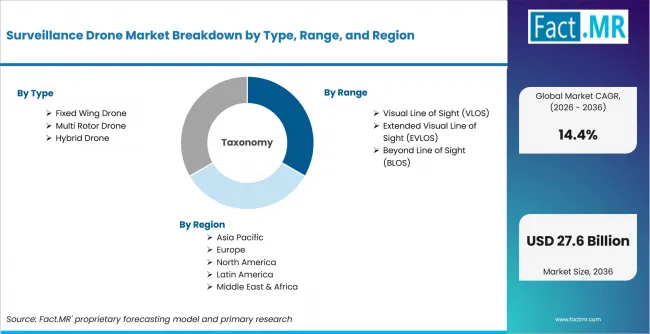
Surveillance Drone Market Breakdown By Type, Range, And Region | Source: Fact.MR
| Attribute | Details |
|---|---|
| Quantitative Units | USD billion |
| Market Definition | Unmanned aerial platforms supplied for surveillance, monitoring, detection, reconnaissance and situational-awareness missions |
| Segments Covered | Type; Range; Mode of Operation; Application |
| Regions Covered | North America; Latin America; Europe; East Asia; South Asia and Pacific; Middle East and Africa |
| Countries Covered | USA; UK; France; Germany; Italy; South Korea; Japan |
| Key Companies Profiled | Aerodyne Group, Airobotics Ltd., BAE Systems Inc., Elbit Systems, Lockheed Martin Corporation, Thales Group, FLIR Systems, Teledyne FLIR, Raytheon Technologies, Leonardo S.p.A., SAAB AB, Percepto, Avitas Systems Inc., Sky-Futures Ltd., Sphere Drone, Tera Drone Corp., Viper Drones, Aesthetix Global, Cyberhawk Innovations Ltd., Martek Aviation, Mistras Group and Azure Drone SAS. |
| Forecast Period | 2026 to 2036 |
| Base Year | 2025 |
| Market Value, 2026 | USD 7.2 billion |
| Market Value, 2036 | USD 27.6 billion |
| CAGR, 2026-2036 | 14.4% |
| Absolute Opportunity | USD 20.4 billion |
| Approach | Hybrid supply- and demand-side analysis using platform shipments, configuration pricing, mission intensity, replacement cycles, procurement programs, operating approvals, range mix and autonomy adoption |
Source: Fact.MR analysis. Updated Aug 26, 2026
How is the market segmented?
-
By Type
- Fixed Wing Drone
- Long Endurance Fixed Wing
- Tactical Fixed Wing
- Commercial Fixed Wing
- Multi Rotor Drone
- Quadcopter Surveillance Drone
- Hexacopter Surveillance Drone
- Octocopter Surveillance Drone
- Hybrid Drone
- Fixed Wing Hybrid Drone
- VTOL Hybrid Drone
- Multi Mission Hybrid Drone
- Fixed Wing Drone
-
By Range
- Visual Line of Sight (VLOS)
- Short Range Surveillance
- Local Area Operations
- Commercial VLOS Missions
- Extended Visual Line of Sight (EVLOS)
- Medium Range Operations
- Industrial Surveillance
- Tactical Monitoring
- Beyond Line of Sight (BLOS)
- Long Range Surveillance
- Military Operations
- Autonomous Missions
- Visual Line of Sight (VLOS)
-
By Mode of Operation
- Remotely Piloted
- Manual Control Systems
- Assisted Flight Operations
- Real Time Monitoring
- Optionally Piloted
- Dual Mode Operations
- Remote Assisted Operations
- Flexible Deployment Systems
- Fully Autonomous
- AI Enabled Surveillance
- Pre Programmed Missions
- Swarm Surveillance Systems
- Remotely Piloted
-
By Application
- Border Surveillance
- Land Border Monitoring
- Remote Border Operations
- Military Border Security
- Coastal and Maritime Patrol
- Coastal Monitoring
- Maritime Surveillance
- Search and Rescue
- Urban Monitoring
- Smart City Surveillance
- Public Safety Operations
- Infrastructure Monitoring
- Industrial Perimeter Surveillance
- Critical Infrastructure Security
- Industrial Site Monitoring
- Asset Protection
- Wildlife and Forest Surveillance
- Forest Monitoring
- Wildlife Protection
- Environmental Monitoring
- Others
- Disaster Management
- Agricultural Surveillance
- Event Surveillance
- Border Surveillance
Frequently Asked Questions
How large is the surveillance drone market in 2025?
What is the expected value of the surveillance drone market in 2026?
What is the forecast value of the surveillance drone market by 2036?
What CAGR is projected for the surveillance drone market from 2026 to 2036?
Which drone type leads the surveillance drone market?
Why do multi-rotor drones lead surveillance drone demand?
Which range segment leads the surveillance drone market?
Why does BLOS demand grow faster in surveillance drone use?
Which mode of operation leads growth in the surveillance drone market?
Which application leads the surveillance drone market?
Which end user leads the surveillance drone market?
Which country is growing fastest in the surveillance drone market?
Why is China growing quickly in the surveillance drone market?
Why is South Korea important in the surveillance drone market?
Which companies compete in the surveillance drone market?
What drives surveillance drone market growth?
What restrains surveillance drone market growth?
How do drones support border surveillance?
How do drones support industrial perimeter security?
What is included in the surveillance drone market scope?
What is excluded from the surveillance drone market scope?
How does Fact.MR forecast surveillance drone demand?
Who worked on this report


Preview the report firsthand - request a free sample
Free SampleGet the brochure for pricing and purchase details
Download PDF