- Market Value (2025): USD 2.8 Bn
- Estimated Value (2026): USD 3.2 Bn
- Forecast Value (2036): USD 11.7 Bn
- CAGR (2026-2036): 13.8%
What is the LiDAR Sensor Market forecast to be worth by 2036?
USD 3.2 billion in 2026 to USD 11.7 billion by 2036, at 13.8% CAGR.
- The LiDAR sensor market crossed a valuation of USD 2.8 billion in 2025 as adoption increased across vehicle sensing and 3D mapping applications.
- Demand is projected to rise from USD 3.2 billion in 2026 to USD 11.7 billion by 2036.
- The market is forecast to register a 13.8% CAGR from 2026 to 2036 as LiDAR deployment expands across mapping and automation applications.
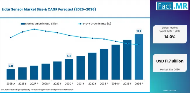
Lidar Sensor Market Value Analysis | Source: Fact.MR
What are the defining numbers behind LiDAR Sensor Market growth?
USD 8.5 billion absolute opportunity by 2036, led by Terrestrial systems and Mechanical LiDAR alongside vehicle-automation programs.
- Demand Drivers in the Market
- Survey organizations are using LiDAR to generate detailed point-cloud data for construction and infrastructure projects.
- Vehicle manufacturers are adopting LiDAR systems to improve depth perception and support advanced driver assistance and automated driving functions.
- Infrastructure agencies rely on LiDAR-based elevation models to support asset inspection, maintenance planning, and digital-twin development.
- Forestry and environmental programs are increasing the use of LiDAR for terrain mapping, vegetation analysis, and surface-change monitoring.
- Key Segments Analyzed
- By Type: Terrestrial is expected to hold 64.3% share in 2026 supported by mobile and static workflows that fit recurring site surveys.
- By Technology: Mechanical LiDAR is projected to account for 62.0% share in 2026 owing to established scanning architectures and broad field use.
- By Application: Vehicle Automation is anticipated to capture 13.8% share in 2026 attributable to perception validation for assisted and automated driving programs.
- By End-use Industry: Automotive is estimated to represent 8.9% share in 2026 driven by OEM qualification work and software-defined perception stacks.
- Analyst Opinion at Fact.MR
- Shambhu Nath Jha, Senior Analyst at Fact.MR, states, “LiDAR adoption is increasingly influenced by system, data quality, and software capabilities. Companies that demonstrate consistent performance and strong validation support are expected to be better positioned for commercial deployment.”
- Strategic Implications
- Vehicle manufacturers are adopting LiDAR systems supported by reliability and validation requirements.
- Survey organizations are using LiDAR solutions shaped by data collection and processing needs.
- Infrastructure agencies are relying on LiDAR data supported by mapping and asset management requirements.
- LiDAR developers are improving calibration and software capabilities to support wider deployment.
Coastal and river mapping projects are increasing demand for airborne LiDAR systems that can capture both land and shallow-water data. Hexagon AG introduced the Leica CoastalMapper in 2025 to support combined topographic and bathymetric surveys.
China is expected to record an 18.9% CAGR through 2036 driven by vehicle sensing and perception-system integration. India is projected to post a 17.5% CAGR supported by mapping programs and drone-based environmental monitoring. Germany is anticipated to advance at a 16.1% CAGR owing to automotive engineering and surveying activities. Brazil is estimated to record a 14.7% CAGR attributable to mobility investment and resource-mapping needs. The United States is forecast to post a 13.3% CAGR reinforced by elevation mapping programs and commercial 3D mapping applications.
How does the LiDAR Sensor Market break down by segment?
Terrestrial leads with 64.3% share by type segment, while Mechanical LiDAR accounts for 62.0% by technology.
Which Type dominates?
Terrestrial holds 64.3% share in 2026.
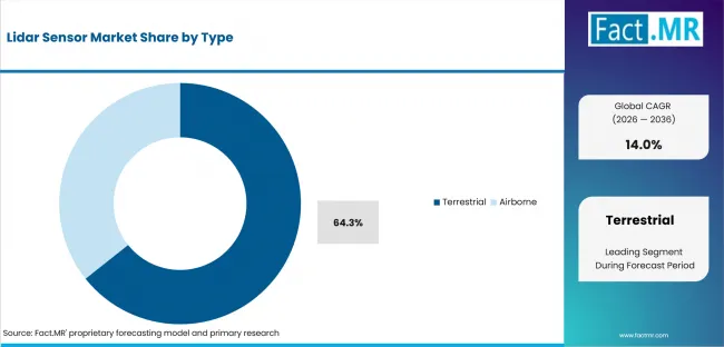
Lidar Sensor Market Analysis By Type | Source: Fact.MR
Terrestrial is expected to hold 64.3% share in 2026 supported by repeatable capture across construction sites and industrial facilities. Mobile LiDAR is widely used for road and rail corridor surveys, while static systems support detailed site mapping. Airborne LiDAR is preferred for large-area mapping projects that require rapid data collection across extensive terrain.
What leads the Technology segment?
Mechanical LiDAR accounts for 62.0% share in 2026.
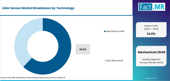
Lidar Sensor Market Analysis By Technology | Source: Fact.MR
Mechanical LiDAR is projected to account for 62.0% share in 2026 owing to established rotating architectures and broad field-service knowledge. Solid State LiDAR is expected to grow as compact sensor designs and production scalability become increasingly important in vehicle development. In September 2025, SICK released validated virtual models for its LiDAR sensors in NVIDIA Isaac Sim, supporting virtual testing during product development.
How does Application shape demand?
Vehicle Automation leads with 14.0% share in 2026.
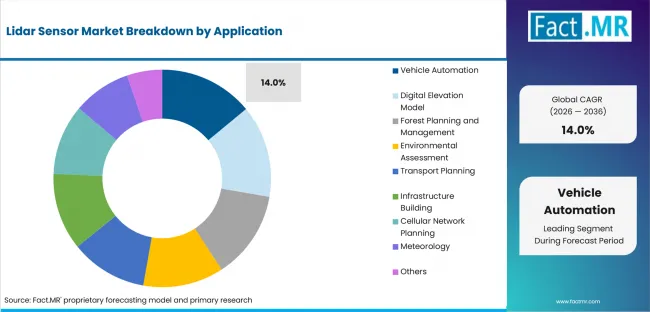
Lidar Sensor Market Analysis By Application | Source: Fact.MR
Vehicle Automation is anticipated to capture 14.0% share in 2026 attributable to perception validation across assisted and automated driving programs. Public agencies use LiDAR for terrain planning and flood analysis. Forestry and environmental programs rely on it for canopy measurement and surface mapping across wide areas.
What supports Automotive demand within End-use Industry?
Automotive holds 8.9% share in 2026.
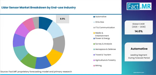
Lidar Sensor Market Analysis By End Use Industry | Source: Fact.MR
Automotive is estimated to represent 8.9% share in 2026 driven by OEM qualification work and sensor-software integration. Survey teams use LiDAR for construction and asset inspection. Power and energy operators apply it for infrastructure monitoring, while agriculture and forestry teams use it for canopy measurement and terrain mapping.
What is accelerating LiDAR Sensor Market adoption, and what is holding it back?
Vehicle automation and three-dimensional mapping drive adoption. Qualification cost and integration complexity restrain it.
Drivers Impact Analysis
| DRIVER | (~) % IMPACT ON CAGR | GEOGRAPHIC RELEVANCE | IMPACT TIMELINE |
|---|---|---|---|
| Vehicle automation and ADAS validation programs | +2.1% | Asia Pacific, Europe and North America | Medium term (2-4 years) |
| Public elevation and three-dimensional mapping programs | +1.8% | North America and Asia Pacific | Long term (>= 4 years) |
| Drone-based surveying and corridor mapping | +1.5% | Asia Pacific and North America | Medium term (2-4 years) |
| Digital-twin maintenance for infrastructure and industry | +1.2% | Europe and North America | Medium term (2-4 years) |
| Climate, forestry and coastal monitoring requirements | +0.9% | Global | Long term (>= 4 years) |
Source: Fact.MR analysis. Updated Jul 14, 2026
- Vehicle automation programs: OEMs are adopting LiDAR systems to support automated driving development. Demand is increasing as advanced driver-assistance features become more common.
- Public elevation programs: Mapping agencies are increasing LiDAR usage for elevation modeling and terrain analysis. Updated elevation data supports flood management and infrastructure planning.
- Drone-based surveying: Survey organizations are using drone-mounted LiDAR systems for data collection across large and hard-to-reach areas. The technology helps improve coverage while reducing survey time.
Opportunity Impact Analysis
| OPPORTUNITY | (~) % IMPACT ON CAGR | GEOGRAPHIC RELEVANCE | IMPACT TIMELINE |
|---|---|---|---|
| Solid State LiDAR for vehicle production programs | +1.0% | China, Germany and United States | Medium term (2-4 years) |
| Bathymetric and coastal mapping productivity | +0.8% | North America, Europe and Asia Pacific | Medium term (2-4 years) |
| Sensor simulation and point-cloud software integration | +0.7% | North America and Europe | Long term (>= 4 years) |
| UAV LiDAR for forestry, mining and infrastructure | +0.6% | India, Brazil and United States | Medium term (2-4 years) |
Source: Fact.MR analysis. Updated Jul 14, 2026
- Solid State LiDAR scale-up: Vehicle manufacturers are increasing demand for compact LiDAR systems that support large-scale production. Software integration is also becoming an important consideration.
- Bathymetric mapping productivity: Coastal authorities are expanding the use of LiDAR for land and shallow-water mapping. Combined survey capabilities help improve efficiency across coastal and infrastructure projects.
- Sensor simulation and software: LiDAR deployments increasingly include software tools for device management and data processing. Integrated hardware and software solutions support market growth.
Restraints Impact Analysis
| RESTRAINT | (~) % IMPACT ON CAGR | GEOGRAPHIC RELEVANCE | IMPACT TIMELINE |
|---|---|---|---|
| Qualification and calibration burden | -0.9% | Automotive and aerospace programs | Short term (<= 2 years) |
| Sensor cost and integration complexity | -0.7% | Global | Medium term (2-4 years) |
| Weather and interference performance limits | -0.6% | Automotive and outdoor robotics | Medium term (2-4 years) |
| Data handling and workflow fragmentation | -0.4% | Surveying and infrastructure | Long term (>= 4 years) |
Source: Fact.MR analysis. Updated Jul 14, 2026
- Qualification burden: Automotive and aerospace programs require extensive testing before adopting new LiDAR systems. Validation requirements can increase costs and deployment timelines.
- Integration complexity: LiDAR systems need to work seamlessly with hardware and software platforms. Integration challenges can slow implementation.
- Weather and interference performance: Environmental conditions such as rain and dust can affect sensor performance. Reliable operation across different conditions remains important.
Which countries are scaling LiDAR Sensor Market fastest?
China 18.9%. India 17.5%. Germany 16.1%. Brazil 14.7%. United States 13.3%.
Regional analysis covers North America and Europe alongside Asia Pacific, with Latin America and the Middle East & Africa completing coverage.
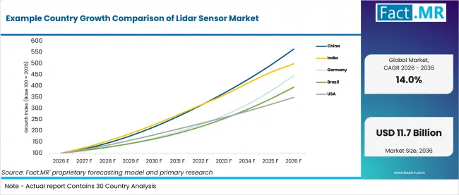
Example Country Growth Comparison Of Lidar Sensor Market | Source: Fact.MR
| COUNTRY | CAGR |
|---|---|
| China | 18.9% |
| India | 17.5% |
| Germany | 16.1% |
| Brazil | 14.7% |
| United States | 13.3% |
Source: Fact.MR analysis. Updated Jul 14, 2026
What is powering LiDAR Sensor demand in China?
18.9% CAGR, driven by vehicle-road-cloud pilots and local perception-system integration.
Vehicle-road-cloud pilots are expanding perception-sensor testing across passenger vehicles and urban fleets in China. The market is expected to record an 18.9% CAGR by 2036, supported by road infrastructure integration and wider field testing across major cities. The State Council Information Office of China reported in June 2025 that pilot activity covered at least 20 cities and city clusters, reinforcing the scale of field testing.
How is India scaling LiDAR Sensor demand?
17.5% CAGR, supported by public mapping and drone-enabled environmental monitoring.
River-basin planning is expanding the use of LiDAR for high-resolution mapping. Demand is projected to advance at a 17.5% CAGR through 2036, driven by flood management and corridor mapping projects.
What supports the LiDAR Sensor outlook in Germany?
16.1% CAGR, owing to automotive engineering depth and industrial survey demand.
Germany is expected to post a 16.1% CAGR from 2026 to 2036, led by automotive engineering and industrial surveying activities. Vehicle manufacturers and industrial operators continue to use LiDAR for testing and site mapping applications.
What supports LiDAR Sensor demand in Brazil?
14.7% CAGR, attributable to mobility investment and resource-mapping requirements.
Brazil is expected to record a 14.7% CAGR through 2036, supported by mobility investments and resource-mapping activities. Growing demand from transport infrastructure projects and field-survey applications continues to support LiDAR adoption across the country.
How is the United States developing LiDAR Sensor demand?
13.3% CAGR, reinforced by national elevation programs and commercial mapping workflows.
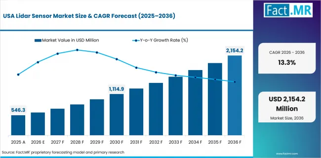
Lidar Sensor Market Country Value Analysis | Source: Fact.MR
The United States is expected to record a 13.3% CAGR from 2026 to 2036, driven by recurring elevation mapping programs and commercial LiDAR applications. Growing demand for updated terrain data continues to create opportunities across mapping and infrastructure.
Who leads the LiDAR Sensor Market?
Hexagon AG and Trimble lead direct geospatial LiDAR coverage, while Valeo and Innoviz Technologies strengthen automotive sensing programs.
Hexagon AG and Trimble lead LiDAR adoption across mapping and surveying applications. Topcon Positioning Systems supports geospatial workflows, while SICK focuses on industrial automation and robotic perception.
Teledyne Technology remains active in airborne laser mapping, while Valeo and Innoviz Technologies strengthen their presence in automotive LiDAR. Competition through 2036 is expected to be shaped by calibration evidence and software interfaces alongside local.
Which companies are the key providers?
Hexagon AG and Trimble are key providers. Topcon Positioning Systems and Teledyne Technology are also profiled. SICK, Valeo and Innoviz Technologies complete the company set.
- Hexagon AG
- Trimble Inc.
- Topcon Positioning Systems
- SICK AG
- Teledyne Technology
- Valeo
- Innoviz Technologies
Bibliography
- European Commission. (2025, March 5). Action plan for the European automotive sector. European Commission.
- German Association of the Automotive Industry. (2026, February 10). Press material for VDA annual press conference 2026. VDA.
- Hesai Technology. (2025, October 3). Hesai becomes the world’s first lidar company to produce 1 million units in 2025. Hesai Technology.
- Hexagon AG. (2025, February 3). New Leica CoastalMapper LiDAR sensor significantly speeds up airborne bathymetric mapping. Hexagon AG.
- International Energy Agency. (2026, May 20). Global EV Outlook 2026. IEA.
This Report Addresses
- The report provides strategic intelligence on LiDAR sensors across Type and Technology choices that shape mapping and automation procurement programs.
- Regional outlook evaluates China and India alongside Germany while Brazil and the United States complete the country growth comparison.
- Competitive analysis profiles Hexagon AG and Trimble alongside Topcon Positioning Systems and Teledyne Technology followed by three active sensing providers.
- Technology assessment covers Mechanical LiDAR and Solid State LiDAR where packaging and calibration requirements create different integration paths.
- Application assessment covers Vehicle Automation and Digital Elevation Models alongside forestry planning and infrastructure tasks that require depth information.
- The forecast framework combines official program evidence with shipment logic, application qualification timing and mapped activity across mapping and vehicle-sensing programs.
What does the LiDAR Sensor Market cover?
Terrestrial and Airborne systems alongside Mechanical and Solid State LiDAR used for three-dimensional sensing and mapping.
The LiDAR Sensor Market covers laser-based sensing systems used to measure distance and generate 3D mapping data. These systems are used across mapping applications as well as vehicle platforms for real-time perception.
The market includes LiDAR sensors and integrated LiDAR systems. Camera-only and radar-only technologies are excluded unless LiDAR is part of the solution.
What is included in the scope?
LiDAR sensor systems used across mapping and automation applications alongside infrastructure and environmental monitoring programs.
The scope includes Terrestrial and Airborne LiDAR systems across Mechanical LiDAR and Solid State LiDAR technologies. Applications include vehicle automation, digital elevation modelling, forestry planning, and environmental assessment. Transport planning and infrastructure projects are also covered where LiDAR provides depth and mapping data.
The market covers automotive, industrial, surveying, and public-sector applications. Automotive LiDAR systems and 3D scanning platforms are included where they support LiDAR-based sensing and mapping workflows.
What is excluded from the scope?
Radar-only perception systems and camera-only three-dimensional imaging systems are outside the scope.
The scope excludes radar-only perception systems and camera-only imaging systems that do not include LiDAR. GNSS receivers, total stations, and drone surveying services are also excluded unless LiDAR sensors are part of the solution.
How was the analysis built?
120+ sources, 35+ company portfolios, 25+ countries, and 20+ industry interviews.
- Primary Research: The primary research framework includes interviews with vehicle manufacturers, survey contractors, infrastructure agencies, LiDAR developers, and geospatial solution providers. It also incorporates input from perception engineers, mapping specialists, asset managers, and system integrators involved in sensor evaluation, qualification, and deployment.
- Desk Research: Desk research evaluates national mapping programs, vehicle automation initiatives, LiDAR product portfolios, regulatory developments, and geospatial technology trends. Company publications, government reports, technical documentation, and industry resources are also reviewed to assess market developments and competitive positioning.
- Market-Sizing and Forecasting: Forecasting uses LiDAR sensor shipments, average selling prices, application adoption rates, and deployment trends across mapping and vehicle-sensing applications. Models also consider public mapping investments, automotive qualification cycles, infrastructure programs, and replacement demand across key end-use sectors.
- Data Validation and Update Cycle: Forecasts are validated through industry interviews and company discussions that test assumptions on technology adoption, qualification requirements, and deployment timelines. Company portfolio reviews, application trends, and regional demand assessments help confirm market direction, while continuous monitoring of product launches, mapping programs, and automotive developments supports forecast updates.
Segmentation
What is the report’s scope and coverage?
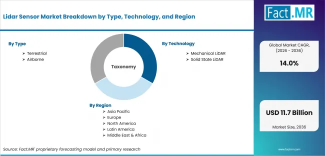
Lidar Sensor Market Breakdown By Type, Technology, And Region | Source: Fact.MR
| ATTRIBUTE | DETAILS |
|---|---|
| Quantitative Units | USD Billion in 2026 to USD Billion by 2036 at CAGR |
| Market Definition | Laser-ranging sensors and integrated LiDAR units that measure returned light to produce distance data and three-dimensional point clouds for mapping, automation and industrial use |
| Type | Terrestrial and Airborne |
| Technology | Mechanical LiDAR; Solid State LiDAR |
| Application | Vehicle Automation; Digital Elevation Model; Forest Planning and Management; Environmental Assessment; Transport Planning; Infrastructure Building; Cellular Network Planning; Meteorology; Others |
| End-use Industry | Automotive; Oil & Gas; IT & Communication; Media & Entertainment; Power & Energy; Survey & Analysis; Aerospace & Defense; Travel & Tourism; Agriculture & Forestry; Mining; Others |
| Regions Covered | North America; Europe; Asia Pacific; Latin America; Middle East & Africa |
| Countries Covered | China; India; Germany; Brazil; United States |
| Key Companies Profiled | Hexagon AG; Trimble Inc.; Topcon Positioning Systems; SICK AG; Teledyne Technology; Valeo; Innoviz Technologies |
| Forecast Period | 2026 to 2036 |
| Approach | Hybrid top-down and bottom-up approach using sensor shipments; average selling prices; public mapping programs; vehicle qualification schedules; application attachment rates; replacement cycles and active portfolio evidence |
Source: Fact.MR analysis. Updated Jul 14, 2026
How is the market segmented?
-
By Type:
- Terrestrial
- Mobile LiDAR
- Static LiDAR
- Airborne
- Topographic LiDAR
- Bathymetric LiDAR
-
By Technology:
- Mechanical LiDAR
- Solid State LiDAR
-
By Application:
- Vehicle Automation
- Digital Elevation Model
- Forest Planning and Management
- Environmental Assessment
- Transport Planning
- Infrastructure Building
- Cellular Network Planning
- Meteorology
- Others
-
By End-use Industry:
- Automotive
- Oil & Gas
- IT & Communication
- Media & Entertainment
- Power & Energy
- Survey & Analysis
- Aerospace & Defense
- Travel & Tourism
- Agriculture & Forestry
- Mining
- Others
-
By Region:
- North America
- United States
- Canada
- Europe
- Germany
- United Kingdom
- France
- Italy
- Spain
- Asia Pacific
- China
- India
- Japan
- South Korea
- Australia
- Latin America
- Brazil
- Argentina
- Mexico
- Chile
- Middle East & Africa
- UAE
- Saudi Arabia
- South Africa
- North America
Frequently Asked Questions
Which Type leads the LiDAR Sensor Market?
Which Technology leads the LiDAR Sensor Market?
Which country records the highest CAGR in the LiDAR Sensor Market?
How does India perform in the LiDAR Sensor Market?
How does Germany perform in the LiDAR Sensor Market?
What is the primary driver in the LiDAR Sensor Market?
What is the main restraint in the LiDAR Sensor Market?
Why are Terrestrial systems important?
Who worked on this report


Preview the report firsthand - request a free sample
Free SampleGet the brochure for pricing and purchase details
Download PDF